File:Lubrizol-Arretes.png
Jump to navigation
Jump to search
Size of this preview: 800 × 566 pixels. Other resolutions: 320 × 226 pixels | 640 × 453 pixels | 1,024 × 724 pixels | 1,280 × 905 pixels | 2,560 × 1,810 pixels | 3,507 × 2,480 pixels.
Original file (3,507 × 2,480 pixels, file size: 923 KB, MIME type: image/png)
Captions
Captions
Add a one-line explanation of what this file represents
Summary
[edit]
| Description |
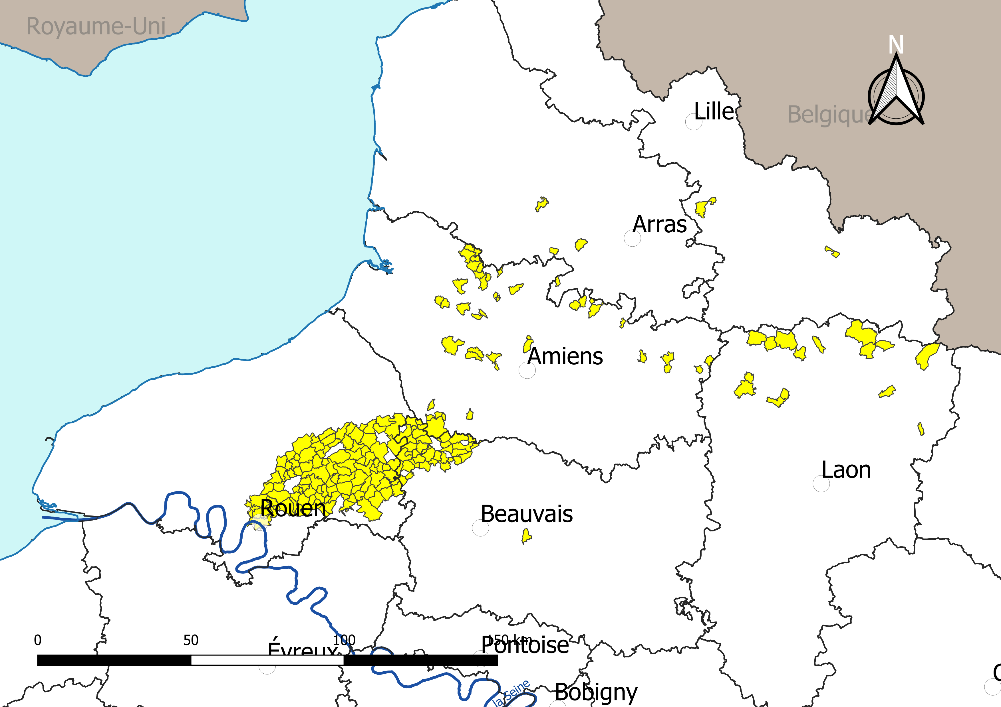
Français : Carte des communes françaises ayant fait l’objet d’arrêtés préfectoraux visant à limiter certaines activités agricoles et à restreindre la mise sur le marché de produits alimentaires d'origine animale et végétale à la suite de l’incendie de l’usine Lubrizol à Rouen (Normandie, France)le 26 septembre 2019.
Carte arrêtée au 2 octobre 2019. English: Map of the french municipalities concerned by a "prefectural decree" limiting certain agricultural activities and restricting the placing on the market of food products which animal and vegetable origin, following the fire of the Lubrizol factory in Rouen (Normandie, France) on September 26, 2019. Map stopped on 2 October 2019.
Nederlands: Kaart van de Franse gemeenten die betrokken zijn bij een "prefectuurbesluit" dat bepaalde landbouwactiviteiten beperkt en het op de markt brengen van voedselproducten van dierlijke en plantaardige oorsprong beperkt, na de brand van de Lubrizol-fabriek in Rouen (Normandie, France) op 26 september 2019. Kaart gestopt op 2 oktober 2019.
Español: Mapa de los municipios franceses afectados por un "decreto de prefectura" que limita ciertas actividades agrícolas y restringe la comercialización de productos alimenticios de origen animal y vegetal, tras el incendio de la fábrica de Lubrizol en Rouen el 26 de septiembre de 2019. El mapa se detuvo el 2 de octubre de 2019.
Deutsch: Karte der französischen Gemeinden, die von einer "Präfekturverordnung" betroffen sind, die bestimmte landwirtschaftliche Tätigkeiten und das Inverkehrbringen von Lebensmitteln tierischen und pflanzlichen Ursprungs nach dem Brand der Lubrizol-Fabrik in Rouen am 26. September 2019 einschränkt 2. Oktober 2019. |
| Date | |
| Source |
Own work sur la base des jeux de données :
|
| Author | Roland45 |
Assemblé et enrichi dans QGis.
Licensing
[edit]
I, the copyright holder of this work, hereby publish it under the following license:
This file is licensed under the Creative Commons Attribution-Share Alike 4.0 International license.
- You are free:
- to share – to copy, distribute and transmit the work
- to remix – to adapt the work
- Under the following conditions:
- attribution – You must give appropriate credit, provide a link to the license, and indicate if changes were made. You may do so in any reasonable manner, but not in any way that suggests the licensor endorses you or your use.
- share alike – If you remix, transform, or build upon the material, you must distribute your contributions under the same or compatible license as the original.
File history
Click on a date/time to view the file as it appeared at that time.
| Date/Time | Thumbnail | Dimensions | User | Comment | |
|---|---|---|---|---|---|
| current | 11:55, 8 October 2019 | | 3,507 × 2,480 (923 KB) | Roland45 (talk | contribs) | Colorisation Royaume Uni |
| 12:04, 5 October 2019 |  | 3,507 × 2,480 (914 KB) | Roland45 (talk | contribs) | changement de teintes | |
| 11:55, 5 October 2019 |  | 3,507 × 2,480 (1,007 KB) | Roland45 (talk | contribs) | == {{int:filedesc}} == {{Information |description={{fr|1=Carte des communes françaises ayant fait l’objet d’arrêtés préfectoraux visant à limiter certaines activités agricoles et à restreindre la mise sur le marché de produits alimentaires d'origine animale et végétale à la suite de l’incendie de l’usine Lubrizol à Rouen.Carte arrêtée au 2 octobre 2019.}} |date=2019-15-05 |source={{own}} sur la base des jeux de données : * Découpage administratif communal et départemental : [https://www.data.... |
You cannot overwrite this file.
File usage on Commons
There are no pages that use this file.
File usage on other wikis
The following other wikis use this file:
- Usage on fr.wikipedia.org