File:Lubawa (gmina wiejska) location map.png

Original file (2,108 × 1,896 pixels, file size: 856 KB, MIME type: image/png)
Captions
Captions
Summary
[edit]_location_map.png&action=edit§ion=1)
| Description |
English: Location map |
| Date | |
| Source | Own work |
| Author | Smat |
| Description |
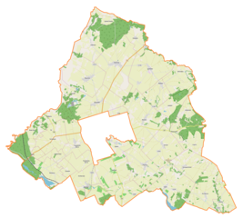
Polski: Mapa gminy wiejskiej Lubawa, Polska
English: Map of Lubawa (gmina wiejska), Poland |
|||||||||
| Date | ||||||||||
| Source | You may find a page on the OpenStreetMap wiki page for Lubawa (gmina wiejska) | |||||||||
| Creator |
OpenStreetMap contributors OpenStreetMap contributors |
|||||||||
| Permission (Reusing this file) |
OpenStreetMap data is available under the Open Database License (details). Map tiles are licensed under the Creative Commons Attribution-ShareAlike 2.0 license (CC-BY-SA 2.0).
This file is licensed under the Creative Commons Attribution-Share Alike 2.0 Generic license.
|
|||||||||
| Geotemporal data | ||||||||||
| Bounding box |
|
|||||||||
| Georeferencing | If inappropriate please set warp_status = skip to hide. | |||||||||
Licensing
[edit]_location_map.png&action=edit§ion=2)
| This work contains information from OpenStreetMap, which is made available under the Open Database License (ODbL).
The ODbL does not require any particular license for maps produced from ODbL data. Prior to 1 August 2020, map tiles produced by the OpenStreetMap Foundation were licensed under the CC-BY-SA-2.0 license. Maps produced by other people may be subject to other licences. |
File history
Click on a date/time to view the file as it appeared at that time.
| Date/Time | Thumbnail | Dimensions | User | Comment | |
|---|---|---|---|---|---|
| current | 14:33, 23 April 2019 | | 2,108 × 1,896 (856 KB) | Smat (talk | contribs) | User created page with UploadWizard |
You cannot overwrite this file.
File usage on Commons
There are no pages that use this file.
File usage on other wikis
The following other wikis use this file:
- Usage on pl.wikipedia.org
- Byszwałd
- Gierłoż Polska
- Kazanice
- Losy
- Lubstyn
- Lubstynek
- Mortęgi
- Omule
- Pomierki
- Prątnica
- Raczek
- Rumienica
- Sampława
- Targowisko Dolne
- Targowisko Górne
- Tuszewo (województwo warmińsko-mazurskie)
- Wałdyki
- Zielkowo
- Czerlin (województwo warmińsko-mazurskie)
- Fijewo (województwo warmińsko-mazurskie)
- Gutowo (województwo warmińsko-mazurskie)
- Ludwichowo (województwo warmińsko-mazurskie)
- Łążyn (województwo warmińsko-mazurskie)
- Rakowice (województwo warmińsko-mazurskie)
- Rożental (województwo warmińsko-mazurskie)
- Złotowo (województwo warmińsko-mazurskie)
- Grabowo (wieś w powiecie iławskim)
- Szczepankowo (powiat iławski)
- Rodzone (gmina Lubawa)
- Napromek (osada w województwie warmińsko-mazurskim)
- Parafia św. Jakuba Apostoła w Kazanicach
- Rakowice (stacja kolejowa)
- Cmentarz żydowski w Lubawie
- Biała Góra (województwo warmińsko-mazurskie)
- Kołodziejki
- Łążek (województwo warmińsko-mazurskie)
- Napromek (osada leśna w województwie warmińsko-mazurskim)
- Osowiec (województwo warmińsko-mazurskie)
- Wiśniewo (powiat iławski)
- Gajówka (województwo warmińsko-mazurskie)
- Grabowo (osada w powiecie iławskim)
- Moduł:Mapa/dane/Lubawa (gmina wiejska)
- Parafia Wniebowzięcia Najświętszej Maryi Panny w Grabowie
- Parafia św. Katarzyny Aleksandryjskiej w Prątnicy
- Parafia św. Wawrzyńca w Rożentalu
- Parafia św. Bartłomieja Apostoła w Sampławie
- Parafia św. Barbary w Złotowie
- Usage on pl.wikibooks.org
_location_map.png&oldid=704002054)