File:Lower end of ditch - geograph.org.uk - 1102114.jpg
Jump to navigation
Jump to search
No higher resolution available.
Lower_end_of_ditch_-_geograph.org.uk_-_1102114.jpg (640 × 480 pixels, file size: 103 KB, MIME type: image/jpeg)
Captions
Captions
Add a one-line explanation of what this file represents
Summary
[edit]
| Description |
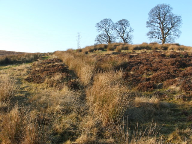
English: Lower end of ditch. This receding line of tufts of vegetation marks the course of a ditch. This channel is artificial, rather than being the natural course of a stream; it is perfectly straight, and stops short of the foot of the slope.
It runs WSW-ENE, from NS 3731 7857 to NS 3735 7858 (the upper and lower end, respectively). It is about 43 metres (140") long, and was evidently associated with a house whose ruins stand beside the upper end of the ditch, in the area in front of the clump of trees. See also 1043828 and 1102137. |
| Date | |
| Source | From geograph.org.uk |
| Author | Lairich Rig |
| Attribution (required by the license) | Lairich Rig / Lower end of ditch / |
| Camera location | | View this and other nearby images on: OpenStreetMap |
|---|
_heading:247.00&language=en)
| Object location | | View this and other nearby images on: OpenStreetMap |
|---|
_heading:247.00&language=en)
Licensing
[edit]

|
This image was taken from the Geograph project collection. See this photograph's page on the Geograph website for the photographer's contact details. The copyright on this image is owned by Lairich Rig and is licensed for reuse under the Creative Commons Attribution-ShareAlike 2.0 license.
|
This file is licensed under the Creative Commons Attribution-Share Alike 2.0 Generic license.
Attribution: Lairich Rig
- You are free:
- to share – to copy, distribute and transmit the work
- to remix – to adapt the work
- Under the following conditions:
- attribution – You must give appropriate credit, provide a link to the license, and indicate if changes were made. You may do so in any reasonable manner, but not in any way that suggests the licensor endorses you or your use.
- share alike – If you remix, transform, or build upon the material, you must distribute your contributions under the same or compatible license as the original.
File history
Click on a date/time to view the file as it appeared at that time.
| Date/Time | Thumbnail | Dimensions | User | Comment | |
|---|---|---|---|---|---|
| current | 18:10, 24 February 2011 | | 640 × 480 (103 KB) | GeographBot (talk | contribs) | == {{int:filedesc}} == {{Information |description={{en|1=Lower end of ditch This receding line of tufts of vegetation marks the course of a ditch. This channel is artificial, rather than being the natural course of a stream; it is perfectly straight, and |
You cannot overwrite this file.
File usage on Commons
There are no pages that use this file.