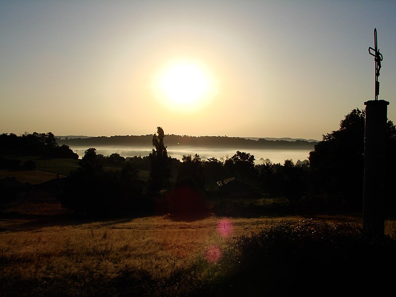
File:Louit sunrise.JPG
From Wikimedia Commons, the free media repository
Jump to navigation
Jump to search

Size of this preview: 800 × 600 pixels. Other resolutions: 320 × 240 pixels | 640 × 480 pixels | 1,024 × 768 pixels | 1,280 × 960 pixels | 2,048 × 1,536 pixels.
Original file (2,048 × 1,536 pixels, file size: 1.02 MB, MIME type: image/jpeg)
File information
Structured data
Captions
Captions
Add a one-line explanation of what this file represents
| DescriptionLouit sunrise.JPG |
Vue du village de Louit dans les Hautes-Pyrénées (France) : Vue du village dans la brume matinale (vue prise depuis le sentier menant à Dours) |
||
| Date |
Français : —————————————————————————————————— * Date et temps de création des données : voir la section "Métadonnées" plus bas, * Importé sur Commons à 23:47, 17 August 2008 (UTC). English: ————————————————————————————— * Date and time of data generation : see the section "Metadata" below, * Uploaded on Commons at 23:47, 17 August 2008 (UTC). |
||
| Source | Own work | ||
| Author | Guérin Nicolas (messages) | ||
| Permission (Reusing this file) |
Travail personnel sous licences libres (voir ci-dessous), choisissez une licence : GFDL si le texte accompagnateur est sous GFDL, Creative Commons CC-BY-SA-3.0 pour tout texte (non libre) sous une autre licence. Ces licences ne concernent que la photo. Application : mettre un lien vers cette page ou sinon la mention "GFDL Guerin Nicolas" ou "cc-by-sa-3.0 Guerin Nicolas" contre la photo. I, the copyright holder of this work, hereby publish it under the following licenses: This file is licensed under the Creative Commons Attribution-Share Alike 3.0 Unported license.
You may select the license of your choice. |
| Camera location | 43° 18′ 13″ N, 0° 09′ 22″ E | View this and other nearby images on: OpenStreetMap |
|---|
File history
Click on a date/time to view the file as it appeared at that time.
| Date/Time | Thumbnail | Dimensions | User | Comment | |
|---|---|---|---|---|---|
| current | 23:47, 17 August 2008 |  | 2,048 × 1,536 (1.02 MB) | Guérin Nicolas (talk | contribs) | {{Information |Description=Vue du village de Louit dans les Hautes-Pyrénées (France) : Vue du village dans la brume matinale (vue prise depuis le sentier menant à Dours) |Source={{fr|œuvre personnelle.}}{{en|own work.}} | |
You cannot overwrite this file.
File usage on Commons
The following 3 pages use this file:
File usage on other wikis
The following other wikis use this file:
- Usage on an.wikipedia.org
- Usage on ca.wikipedia.org
- Usage on ceb.wikipedia.org
- Usage on ce.wikipedia.org
- Usage on en.wikipedia.org
- Usage on eu.wikipedia.org
- Usage on fr.wikipedia.org
- Usage on hu.wikipedia.org
- Usage on it.wikipedia.org
- Usage on la.wikipedia.org
- Usage on ms.wikipedia.org
- Usage on oc.wikipedia.org
- Usage on pl.wikipedia.org
- Usage on ro.wikipedia.org
- Usage on ru.wikipedia.org
- Usage on sk.wikipedia.org
- Usage on sv.wikipedia.org
- Usage on tt.wikipedia.org
- Usage on uk.wikipedia.org
- Usage on vec.wikipedia.org
- Usage on vi.wikipedia.org
- Usage on www.wikidata.org
- Usage on zh-min-nan.wikipedia.org
Metadata
This file contains additional information such as Exif metadata which may have been added by the digital camera, scanner, or software program used to create or digitize it. If the file has been modified from its original state, some details such as the timestamp may not fully reflect those of the original file. The timestamp is only as accurate as the clock in the camera, and it may be completely wrong.
| Camera manufacturer | SONY |
|---|---|
| Camera model | DSC-H5 |
| Exposure time | 1/1,600 sec (0.000625) |
| F-number | f/5.6 |
| ISO speed rating | 125 |
| Date and time of data generation | 06:35, 6 August 2008 |
| Lens focal length | 7.5 mm |
| Orientation | Normal |
| Horizontal resolution | 72 dpi |
| Vertical resolution | 72 dpi |
| File change date and time | 06:35, 6 August 2008 |
| Y and C positioning | Co-sited |
| Exposure Program | Normal program |
| Exif version | 2.21 |
| Date and time of digitizing | 06:35, 6 August 2008 |
| Meaning of each component |
|
| Image compression mode | 8 |
| APEX exposure bias | 0.3 |
| Maximum land aperture | 3 APEX (f/2.83) |
| Metering mode | Pattern |
| Light source | Unknown |
| Flash | Flash did not fire, compulsory flash suppression |
| Supported Flashpix version | 1 |
| Color space | sRGB |
| File source | Digital still camera |
| Scene type | A directly photographed image |
| Custom image processing | Normal process |
| Exposure mode | Manual exposure |
| White balance | Auto white balance |
| Scene capture type | Standard |
| Contrast | Normal |
| Saturation | Normal |
| Sharpness | Normal |
