File:Lost Lake (33626769485).jpg

Original file (5,472 × 3,278 pixels, file size: 13.5 MB, MIME type: image/jpeg)
Captions
Captions
Summary
[edit].jpg&action=edit§ion=1)
| Description |
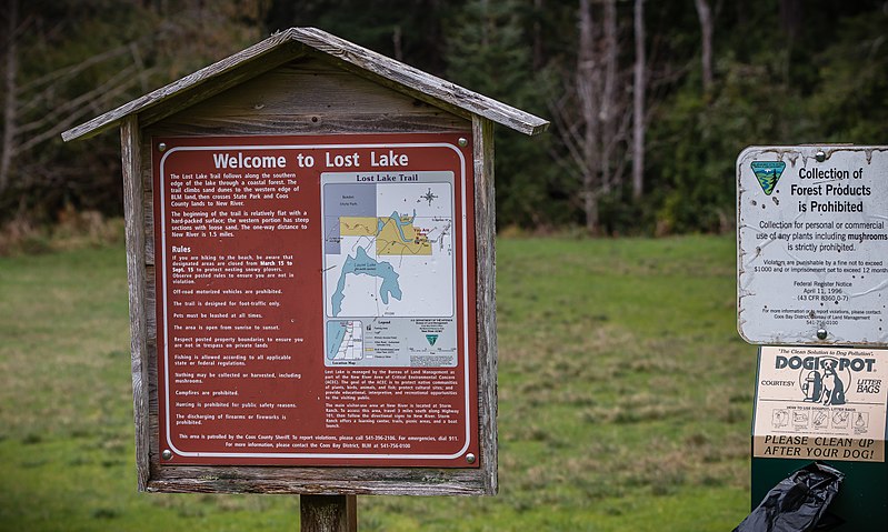
Informational signs at parking area and trailhead for Lost Lake, Mar. 15, 2016, by Greg Shine, BLM. A small freshwater lake surrounded by a peaceful coastal forest, the Lost Lake unit of the New River Area of Critical Environmental Concern (ACEC) provides a quiet, contemplative location for hiking, birdwatching, and picnicking on Oregon’s South Coast. One of approximately 20 lakes in Oregon named Lost Lake, this one features a hiking trail with scenic lakeside views and a connection to the New River through neighboring Bandon State Natural Area. The trail begins at the small parking lot and follows the southern and western sides of the lake through a mature coastal forest. The beginning of the trail is flat with a hard-packed surface; the western portion has steep sections with loose sand. The one-way distance to New River is approximately 1.5 miles. Running parallel to the Pacific Ocean for nine miles, New River is separated from the ocean by only a thin foredune of sand. Many rare birds, animals, and plants depend on New River's estuary, forest, meadow, wetland, and shrub habitat for survival. Dedicated almost exclusively to Watchable Wildlife, the area remains secluded and primitive, providing nature enthusiasts with short, rustic, self-guided loop trails to view wildlife. There are four main access points to New River ACEC: Storm Ranch, Floras Lake, Lost Lake, and Fourmile Creek. For more information, please contact: BLM Coos Bay District Office 1300 Airport Lane North Bend, OR 97459 (541) 756-0100 |
| Date | |
| Source | Lost Lake |
| Author | Bureau of Land Management Oregon and Washington from Portland, America |
Licensing
[edit].jpg&action=edit§ion=2)
- You are free:
- to share – to copy, distribute and transmit the work
- to remix – to adapt the work
- Under the following conditions:
- attribution – You must give appropriate credit, provide a link to the license, and indicate if changes were made. You may do so in any reasonable manner, but not in any way that suggests the licensor endorses you or your use.
| This image was originally posted to Flickr by BLMOregon at https://flickr.com/photos/50169152@N06/33626769485 (archive). It was reviewed on 13 May 2018 by FlickreviewR 2 and was confirmed to be licensed under the terms of the cc-by-2.0. |
| This image is a work of a Bureau of Land Management* employee, taken or made as part of that person's official duties. As a work of the U.S. federal government, the image is in the public domain in the United States. *or predecessor organization |
| This image is a work of a Bureau of Land Management* employee, taken or made as part of that person's official duties. As a work of the U.S. federal government, the image is in the public domain in the United States. *or predecessor organization |
File history
Click on a date/time to view the file as it appeared at that time.
| Date/Time | Thumbnail | Dimensions | User | Comment | |
|---|---|---|---|---|---|
| current | 23:32, 13 May 2018 | | 5,472 × 3,278 (13.5 MB) | OceanAtoll (talk | contribs) | Transferred from Flickr via #flickr2commons |
You cannot overwrite this file.
File usage on Commons
There are no pages that use this file.
.jpg&oldid=877867005)