File:Longuitasko mendilerroa.png
Jump to navigation
Jump to search
No higher resolution available.
Longuitasko_mendilerroa.png (473 × 448 pixels, file size: 457 KB, MIME type: image/png)
Captions
Captions
Add a one-line explanation of what this file represents
Summary
[edit]| Description |
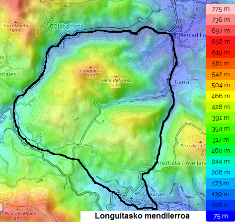
Euskara: Longuitasko mendilerroaren mapa topografikoa.
English: Topographic map showing the Longuitas mountain range.
Français : Carte topographique du massif de Longuitas.
Español: Mapa topografico de la sierra de Longuitas. |
|||||
| Date | ||||||
| Source |
Own work Map data & imagery © OpenStreetMap Leaflet, an open-source JavaScript library Topographic-map.com, Visualisation et partage de cartes topographiques gratuites. |
|||||
| Author |
|

File history
Click on a date/time to view the file as it appeared at that time.
| Date/Time | Thumbnail | Dimensions | User | Comment | |
|---|---|---|---|---|---|
| current | 01:40, 1 December 2023 | | 473 × 448 (457 KB) | Zorion (talk | contribs) | mispelled title |
| 20:01, 21 September 2019 |  | 473 × 448 (457 KB) | Zorion (talk | contribs) | User created page with UploadWizard |
You cannot overwrite this file.
File usage on Commons
The following 2 pages use this file:
- File:Longuitaseko mendilerroa.png (file redirect)
- File:Longuitasko mendilerroa.png
File usage on other wikis
The following other wikis use this file:
- Usage on eu.wikipedia.org
- Usage on www.wikidata.org