File:Long barrow on Bokerley Down - geograph.org.uk - 673985.jpg
Jump to navigation
Jump to search
No higher resolution available.
Long_barrow_on_Bokerley_Down_-_geograph.org.uk_-_673985.jpg (640 × 427 pixels, file size: 83 KB, MIME type: image/jpeg)
Captions
Captions
Add a one-line explanation of what this file represents
Summary
[edit]
| Description |
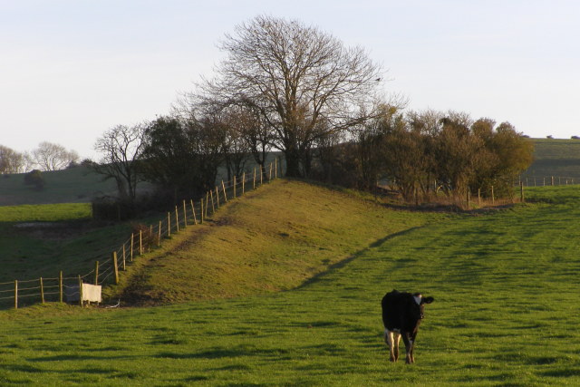
English: Long barrow on Bokerley Down This long barrow is located on the slope of a spur of Pentridge Hill (called Bokerley Down on the OS map) that extends northwards towards Martin Down. At just over 100m in length it is the second longest long barrow in the Cranborne Chase group, exceeded only by the Pimperne long barrow. This barrow is unusual in that it cuts across the contours of the slope (pointing downhill) rather than following the contours like the other long barrows in the area. A possible explanation for this anomaly is that it aligns the barrow with the (no longer visible) earthworks of the north-eastern terminal of the Dorset Cursus.
The barrow currently finds itself divided along its long axis by a fence, with its eastern flank in an "access land" field. It is in fairly good condition, grazed by sheep, with trees on its broader southern end. A bridleway from Pentridge village to Martin Down national nature reserve passes to the north of the barrow. |
| Date | |
| Source | From geograph.org.uk |
| Author | Jim Champion |
| Attribution (required by the license) | Jim Champion / Long barrow on Bokerley Down / |
| Camera location | | View this and other nearby images on: OpenStreetMap |
|---|
_heading:135.00&language=en)
| Object location | | View this and other nearby images on: OpenStreetMap |
|---|
_heading:135.00&language=en)
Licensing
[edit]

|
This image was taken from the Geograph project collection. See this photograph's page on the Geograph website for the photographer's contact details. The copyright on this image is owned by Jim Champion and is licensed for reuse under the Creative Commons Attribution-ShareAlike 2.0 license.
|
This file is licensed under the Creative Commons Attribution-Share Alike 2.0 Generic license.
Attribution: Jim Champion
- You are free:
- to share – to copy, distribute and transmit the work
- to remix – to adapt the work
- Under the following conditions:
- attribution – You must give appropriate credit, provide a link to the license, and indicate if changes were made. You may do so in any reasonable manner, but not in any way that suggests the licensor endorses you or your use.
- share alike – If you remix, transform, or build upon the material, you must distribute your contributions under the same or compatible license as the original.
- Remove redundant categories and try to put this image in the most specific category/categories
- Remove this template
- The location categories are based on information from this geonames tool and this OpenStreetMap tool combined with a database. You can also have a look at this tool from mysociety.
- The topic category from Geograph was Ancient mound (find similar images mound at Geograph)
File history
Click on a date/time to view the file as it appeared at that time.
| Date/Time | Thumbnail | Dimensions | User | Comment | |
|---|---|---|---|---|---|
| current | 22:33, 7 February 2011 | | 640 × 427 (83 KB) | GeographBot (talk | contribs) | == {{int:filedesc}} == {{Information |description={{en|1=Long barrow on Bokerley Down This long barrow is located on the slope of a spur of Pentridge Hill (called Bokerley Down on the OS map) that extends northwards towards Martin Down. At just over 100m |
You cannot overwrite this file.
File usage on Commons
There are no pages that use this file.