File:LongWinA36RtMap.png
Jump to navigation
Jump to search
Size of this preview: 547 × 600 pixels. Other resolutions: 219 × 240 pixels | 438 × 480 pixels | 701 × 768 pixels | 934 × 1,024 pixels | 2,029 × 2,224 pixels.
Original file (2,029 × 2,224 pixels, file size: 399 KB, MIME type: image/png)
Captions
Captions
Add a one-line explanation of what this file represents
Summary
[edit]
| Description |
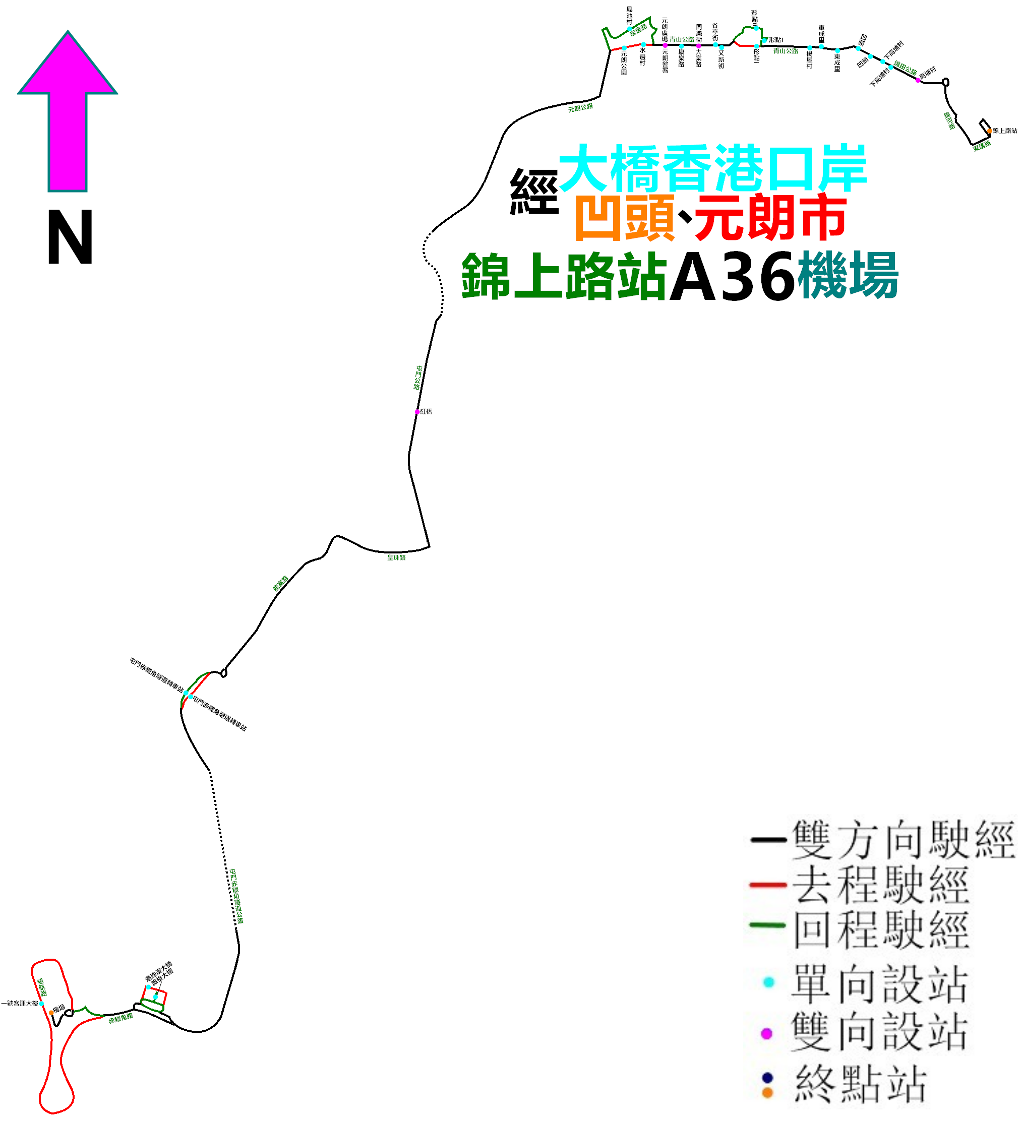
中文(香港):龍運巴士A36線的走線圖 |
| Date | |
| Source | Own work |
| Author | ATR50 |
Licensing
[edit]
I, the copyright holder of this work, hereby publish it under the following license:
This file is licensed under the Creative Commons Attribution-Share Alike 4.0 International license.
- You are free:
- to share – to copy, distribute and transmit the work
- to remix – to adapt the work
- Under the following conditions:
- attribution – You must give appropriate credit, provide a link to the license, and indicate if changes were made. You may do so in any reasonable manner, but not in any way that suggests the licensor endorses you or your use.
- share alike – If you remix, transform, or build upon the material, you must distribute your contributions under the same or compatible license as the original.
File history
Click on a date/time to view the file as it appeared at that time.
| Date/Time | Thumbnail | Dimensions | User | Comment | |
|---|---|---|---|---|---|
| current | 14:44, 27 June 2021 | | 2,029 × 2,224 (399 KB) | ATR50~commonswiki (talk | contribs) | 2021年6月20日改經屯赤隧道 |
| 14:51, 13 December 2019 |  | 2,261 × 2,230 (756 KB) | ATR50~commonswiki (talk | contribs) | 2019年11月尾不再經2號客運大樓 | |
| 02:25, 5 December 2018 |  | 2,261 × 2,230 (759 KB) | ATR50~commonswiki (talk | contribs) | 往元朗方向改經順朗路直上北嶼 | |
| 17:11, 26 October 2018 |  | 1,661 × 2,750 (714 KB) | ATR50~commonswiki (talk | contribs) | 配合港珠澳大橋香港口岸啟用,來回程皆繞經該處 | |
| 03:06, 10 October 2017 |  | 1,661 × 2,750 (695 KB) | ATR50~commonswiki (talk | contribs) | 增停「宏富苑」分站 | |
| 16:24, 31 July 2017 |  | 1,661 × 2,750 (694 KB) | ATR50~commonswiki (talk | contribs) | 2017年初改停「形點1」 | |
| 15:38, 7 September 2016 |  | 1,661 × 2,750 (690 KB) | ATR50~commonswiki (talk | contribs) | 2016年8月修改元朗端走線 | |
| 03:58, 14 April 2016 |  | 2,374 × 2,383 (979 KB) | ATR50~commonswiki (talk | contribs) | 2016年4月補圖 | |
| 03:12, 3 October 2015 |  | 2,374 × 2,383 (234 KB) | ATR50~commonswiki (talk | contribs) | User created page with UploadWizard |
You cannot overwrite this file.
File usage on Commons
The following 40 pages use this file:
- User:Chumwa/OgreBot/Potential transport maps/2016 April 11-20
- User:Chumwa/OgreBot/Potential transport maps/2016 September 1-10
- User:Chumwa/OgreBot/Potential transport maps/2017 July 21-31
- User:Chumwa/OgreBot/Potential transport maps/2017 October 1-10
- User:Chumwa/OgreBot/Potential transport maps/2018 December 1-10
- User:Chumwa/OgreBot/Potential transport maps/2018 October 21-31
- User:Chumwa/OgreBot/Potential transport maps/2019 December 11-20
- User:Chumwa/OgreBot/Public transport information/2015 October 1-10
- User:Chumwa/OgreBot/Public transport information/2016 April 11-20
- User:Chumwa/OgreBot/Public transport information/2016 September 1-10
- User:Chumwa/OgreBot/Public transport information/2017 July 21-31
- User:Chumwa/OgreBot/Public transport information/2017 October 1-10
- User:Chumwa/OgreBot/Public transport information/2018 December 1-10
- User:Chumwa/OgreBot/Public transport information/2018 October 21-31
- User:Chumwa/OgreBot/Public transport information/2019 December 11-20
- User:Chumwa/OgreBot/Public transport information/2021 June 21-30
- User:Chumwa/OgreBot/Transport Maps/2015 October 1-10
- User:Chumwa/OgreBot/Transport Maps/2016 April 11-20
- User:Chumwa/OgreBot/Transport Maps/2016 September 1-10
- User:Chumwa/OgreBot/Transport Maps/2017 July 21-31
- User:Chumwa/OgreBot/Transport Maps/2017 October 1-10
- User:Chumwa/OgreBot/Transport Maps/2018 December 1-10
- User:Chumwa/OgreBot/Transport Maps/2018 October 21-31
- User:Chumwa/OgreBot/Transport Maps/2019 December 11-20
- User:Chumwa/OgreBot/Transport Maps/2021 June 21-30
- User:Chumwa/OgreBot/Travel and communication maps/2016 April 11-20
- User:Chumwa/OgreBot/Travel and communication maps/2016 September 1-10
- User:Chumwa/OgreBot/Travel and communication maps/2017 July 21-31
- User:Chumwa/OgreBot/Travel and communication maps/2017 October 1-10
- User:Chumwa/OgreBot/Travel and communication maps/2018 December 1-10
- User:Chumwa/OgreBot/Travel and communication maps/2018 October 21-31
- User:Chumwa/OgreBot/Travel and communication maps/2019 December 11-20
- User:Chumwa/OgreBot/Travel and communication maps/2021 June 21-30
- User:OgreBot/Watercraft/2016 September 7
- User:OgreBot/Watercraft/2017 July 31
- User:OgreBot/Watercraft/2017 October 10
- User:OgreBot/Watercraft/2018 December 5
- User:OgreBot/Watercraft/2018 October 26
- User:Pechristener/Bridges/2015 October 1-10
- Commons:WikiProject Aviation/recent uploads/2019 December 13
File usage on other wikis
The following other wikis use this file:
- Usage on zh.wikipedia.org