File:Loma Prieta Earthquake - On October 17, 1989, a magnitude 6.9 earthquake.jpg
Original file (3,072 × 2,048 pixels, file size: 1.45 MB, MIME type: image/jpeg)
Captions
Captions
Summary
[edit]
| Description |
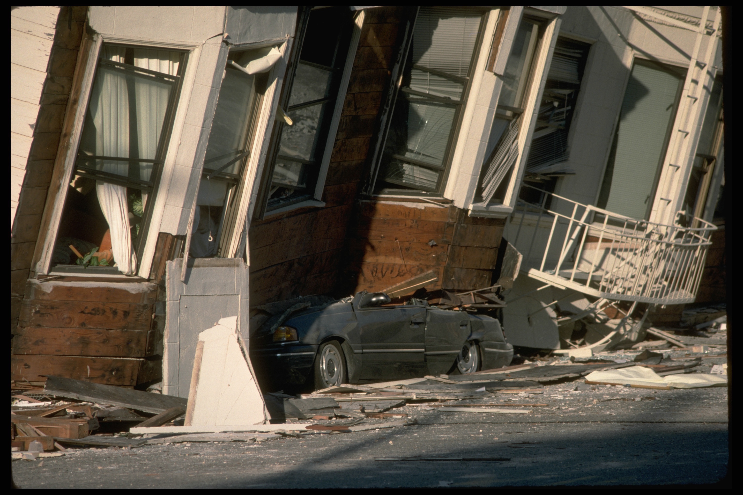
English: Today marks the 25th anniversary of a devastating earthquake that struck the San Francisco area. On October 17, 1989, at 5:04:15 p.m. (PDT), a magnitude 6.9 earthquake severely shook the San Francisco and Monterey Bay regions. The epicenter was located near Loma Prieta peak in the Santa Cruz Mountains.
The 1989 Loma Prieta earthquake ended decades of tranquility in the San Francisco Bay region. It was a wakeup call to prepare for the potentially even more devastating shocks that are inevitable in the future. Since 1989, the work of the U.S. Geological Survey and other organizations has improved understanding of the seismic threat in the Bay region, promoted awareness of earthquake hazards, and contributed to more effective strategies to reduce earthquake losses. These efforts will help reduce the impact of future large quakes in the San Francisco Bay region. In this photo: An automobile lies crushed under the third story of this apartment building in the Marina District. The ground levels are no longer visible because of structural failure and sinking due to liquefaction. [J.K. Nakata, USGS] Learn more about what happened, many more photos and maps at bit.ly/LomaPrieta |
| Date | |
| Source | https://www.flickr.com/photos/27784370@N05/15369566688/ |
| Author | U.S. Geological Survey |
Licensing
[edit]
| This file is made available under the Creative Commons CC0 1.0 Universal Public Domain Dedication. | |
| The person who associated a work with this deed has dedicated the work to the public domain by waiving all of their rights to the work worldwide under copyright law, including all related and neighboring rights, to the extent allowed by law. You can copy, modify, distribute and perform the work, even for commercial purposes, all without asking permission.
|
| This image was originally posted to Flickr by U.S. Geological Survey at https://flickr.com/photos/27784370@N05/15369566688. It was reviewed on 19 January 2022 by FlickreviewR 2 and was confirmed to be licensed under the terms of the cc-zero. |
File history
Click on a date/time to view the file as it appeared at that time.
| Date/Time | Thumbnail | Dimensions | User | Comment | |
|---|---|---|---|---|---|
| current | 05:49, 19 January 2022 | | 3,072 × 2,048 (1.45 MB) | Ooligan (talk | contribs) | Uploaded a work by U.S. Geological Survey from https://www.flickr.com/photos/27784370@N05/15369566688/ with UploadWizard |
You cannot overwrite this file.
File usage on Commons
There are no pages that use this file.