File:Lokasi Sulawesi Barat Kabupaten Mamasa.svg
Jump to navigation
Jump to search

Size of this PNG preview of this SVG file: 800 × 539 pixels. Other resolutions: 320 × 216 pixels | 640 × 431 pixels | 1,024 × 690 pixels | 1,280 × 863 pixels | 2,560 × 1,726 pixels | 1,774 × 1,196 pixels.
Original file (SVG file, nominally 1,774 × 1,196 pixels, file size: 469 KB)
Captions
Captions
Add a one-line explanation of what this file represents
Summary
[edit]
| Description |
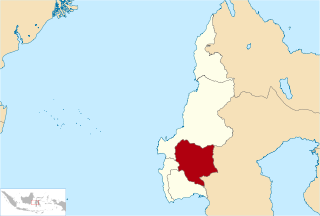
Bahasa Indonesia: Lokasi Kabupaten Mamasa di Provinsi Sulawesi Barat
English: Location of Mamasa Regency in West Sulawesi Province, Indonesia |
| Date | 26 July 2010 (original upload date) |
| Source | Transferred from id.wikipedia; transferred to Commons by User:Jack Merridew using CommonsHelper. |
| Author | Original uploader was Ewesewes at id.wikipedia |
| Permission (Reusing this file) |
CC-BY-SA-3.0. |
Licensing
[edit]
Ewesewes at id.wikipedia, the copyright holder of this work, hereby publishes it under the following license:
This file is licensed under the Creative Commons Attribution-Share Alike 3.0 Unported license.
Attribution: Ewesewes at id.wikipedia
- You are free:
- to share – to copy, distribute and transmit the work
- to remix – to adapt the work
- Under the following conditions:
- attribution – You must give appropriate credit, provide a link to the license, and indicate if changes were made. You may do so in any reasonable manner, but not in any way that suggests the licensor endorses you or your use.
- share alike – If you remix, transform, or build upon the material, you must distribute your contributions under the same or compatible license as the original.
Original upload log
[edit]
The original description page was here. All following user names refer to id.wikipedia.
- 2010-07-26 17:23 Ewesewes 1774×1196× (479978 bytes) Lokasi Kabupaten Mamasa di Provinsi Sulawesi Barat [[Kategori:Peta penunjuk posisi di Indonesia]] == Jenis lisensi == {{Self|Cc-by-sa-3.0}}
File history
Click on a date/time to view the file as it appeared at that time.
| Date/Time | Thumbnail | Dimensions | User | Comment | |
|---|---|---|---|---|---|
| current | 23:29, 25 February 2011 | | 1,774 × 1,196 (469 KB) | File Upload Bot (Magnus Manske) (talk | contribs) | {{BotMoveToCommons|id.wikipedia|year={{subst:CURRENTYEAR}}|month={{subst:CURRENTMONTHNAME}}|day={{subst:CURRENTDAY}}}} {{Information |Description={{id|Lokasi Kabupaten Mamasa di Provinsi Sulawesi Barat id:Kategori:Peta penunjuk posisi di Indonesia |
You cannot overwrite this file.
File usage on Commons
The following page uses this file:
File usage on other wikis
The following other wikis use this file:
- Usage on ban.wikipedia.org
- Usage on de.wikipedia.org
- Usage on en.wikipedia.org
- Usage on frr.wikipedia.org
- Usage on id.wikipedia.org
- Usage on it.wikipedia.org
- Usage on jv.wikipedia.org
- Usage on ml.wikipedia.org
- Usage on ms.wikipedia.org
- Usage on nl.wikipedia.org
- Usage on ru.wikipedia.org
- Usage on simple.wikipedia.org
- Usage on su.wikipedia.org
- Usage on www.wikidata.org
- Usage on zh-min-nan.wikipedia.org
- Usage on zh.wikipedia.org