File:Lohsa Dreiweiberner See Ueberleitung Lohsa II Aerial.jpg
From Wikimedia Commons, the free media repository
Jump to navigation
Jump to search
Size of this preview: 800 × 515 pixels. Other resolutions: 320 × 206 pixels | 640 × 412 pixels | 1,024 × 659 pixels | 1,280 × 824 pixels | 2,560 × 1,648 pixels | 5,276 × 3,397 pixels.
Original file (5,276 × 3,397 pixels, file size: 5.68 MB, MIME type: image/jpeg)
File information
Structured data
Captions
Summary
[edit]DescriptionLohsa Dreiweiberner See Ueberleitung Lohsa II Aerial.jpg |
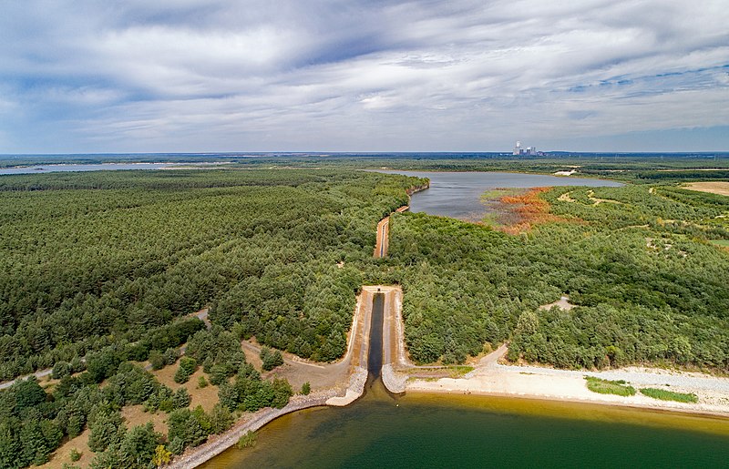
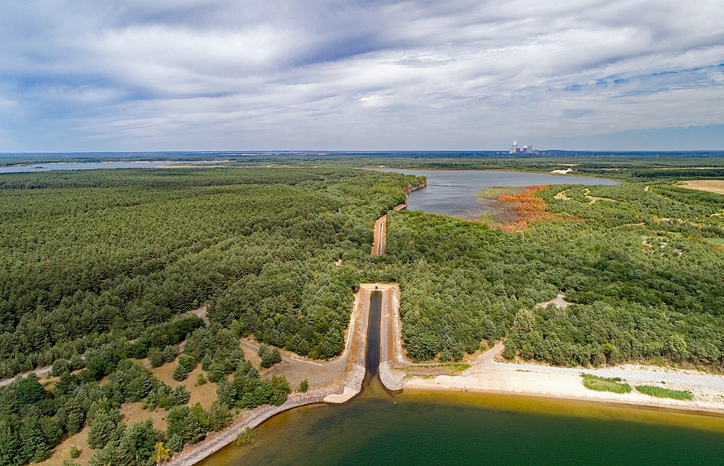
English: Dreiweiberner See to Speichebecken Lohsa II (Lohsa, Saxony, Germany)
Hornjoserbsce: Wotwod z Třižonjanskeho jězora do spjateho wódnika Łaz II |
Date | |
Source | Own work |
Author | PaulT (Gunther Tschuch) |
Camera location | 51° 24′ 13.83″ N, 14° 25′ 39.59″ E | View this and other nearby images on: OpenStreetMap | 51.403842; 14.427664 |
---|
Licensing
[edit]I, the copyright holder of this work, hereby publish it under the following license:
This file is licensed under the Creative Commons Attribution-Share Alike 4.0 International license.
- You are free:
- to share – to copy, distribute and transmit the work
- to remix – to adapt the work
- Under the following conditions:
- attribution – You must give appropriate credit, provide a link to the license, and indicate if changes were made. You may do so in any reasonable manner, but not in any way that suggests the licensor endorses you or your use.
- share alike – If you remix, transform, or build upon the material, you must distribute your contributions under the same or compatible license as the original.
Annotations InfoField | This image is annotated: View the annotations at Commons |
1332
2975
3917
416
5276
3397
Dreiweiberner See
2513
1504
376
1372
5276
3397
Überleitungsbauwerk
2922
1207
1576
449
5276
3397
Speicherbecken Lohsa II
20
1148
1774
112
5276
3397
Speicherbecken Lohsa II
3680
1009
270
132
5276
3397
Boxberg
File history
Click on a date/time to view the file as it appeared at that time.
Date/Time | Thumbnail | Dimensions | User | Comment | |
---|---|---|---|---|---|
current | 08:45, 8 July 2018 | 5,276 × 3,397 (5.68 MB) | PaulT (talk | contribs) | User created page with UploadWizard |
You cannot overwrite this file.
File usage on Commons
The following 2 pages use this file:
Metadata
This file contains additional information such as Exif metadata which may have been added by the digital camera, scanner, or software program used to create or digitize it. If the file has been modified from its original state, some details such as the timestamp may not fully reflect those of the original file. The timestamp is only as accurate as the clock in the camera, and it may be completely wrong.
Image title |
|
---|---|
Camera manufacturer | DJI |
Camera model | FC6310 |
Copyright holder |
|
Exposure time | 1/240 sec (0.0041666666666667) |
F-number | f/5 |
ISO speed rating | 100 |
Date and time of data generation | 15:45, 7 July 2018 |
Lens focal length | 8.8 mm |
Latitude | 51° 24′ 13.83″ N |
Longitude | 14° 25′ 39.59″ E |
Altitude | 169 meters above sea level |
Orientation | Normal |
Horizontal resolution | 300 dpi |
Vertical resolution | 300 dpi |
Software used | Adobe Photoshop Elements 15.0 (Windows) |
File change date and time | 15:45, 7 July 2018 |
Exposure Program | Normal program |
Exif version | 2.3 |
Date and time of digitizing | 15:45, 7 July 2018 |
APEX shutter speed | 7.906891 |
APEX aperture | 4.643856 |
APEX exposure bias | 0 |
Maximum land aperture | 2.97 APEX (f/2.8) |
Subject distance | 0 meters |
Metering mode | Center weighted average |
Light source | Unknown |
Flash | Flash did not fire, No flash function |
Color space | sRGB |
File source | Digital still camera |
Scene type | A directly photographed image |
Custom image processing | Normal process |
Exposure mode | Auto exposure |
White balance | Auto white balance |
Digital zoom ratio | 0 |
Focal length in 35 mm film | 24 mm |
Scene capture type | Standard |
Scene control | None |
Contrast | Normal |
Saturation | Normal |
Sharpness | Normal |
Subject distance range | Unknown |
GPS time (atomic clock) | 15:45 |
Reference for direction of image | True direction |
Direction of image | 55 |
GPS date | 7 July 2018 |
GPS tag version | 0.0.3.2 |
IIM version | 44,566 |
Lens used | 24.0 mm |
Serial number of camera | 6cd6f63700faa12c9fbb841d72ebe9ee |
Geodetic survey data used | WGS-84 |
Date metadata was last modified | 09:52, 8 July 2018 |
Unique ID of original document | 7D2F8C477FDE95DB8F157451C90F1746 |