File:Lofoten, Norway ESA23991695.jpeg

Original file (8,337 × 13,895 pixels, file size: 47.16 MB, MIME type: image/jpeg)
Captions
Captions
Summary
[edit]| Warning | The original file is very high-resolution. It might not load properly or could cause your browser to freeze when opened at full size. |
|---|
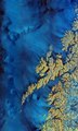
| Description |
English: The Copernicus Sentinel-1 mission takes us over the archipelago of Lofoten in northern Norway. Zoom in to see this image at its full resolution or click on the circles to learn more about the features in it. Extending around 175 km from north to south, the archipelago comprises five main islands (Austvågøya, Gimsøya, Vestvågøya, Flakstadøya, and Moskenesøya), as well as many small islands and skerries (rocky islets and reefs). Lofoten is known for its distinctive scenery, with dramatic mountains and peaks, sweeping beaches, deep blue fjords and sheltered bays. Svolvær, the chief town and port of the Lofoten island group, is located on the southern coast of Austvågøya, the easternmost island of the archipelago. The economy largely depends on cod fisheries, with the town’s population swelling during the spawning season as fishermen flock in. The fjord of Vestfjorden lies between the archipelago and the mainland. Although lying entirely within the Arctic Circle, Lofoten experiences one of the world’s largest elevated temperature anomalies relative to its high latitude. Due to a convergence of the Gulf Stream with two underwater currents, the North Atlantic Current and the Norwegian Current, the weather in Lofoten remains anomalously warm. The colours of this week’s image come from the combination of two ‘polarisations’ from the Copernicus Sentinel-1 mission which have been converted into a single image. This remote sensing technique allows us to detect where differences between the polarisations are higher. These differences are visible in shades of blue in the image, such as the choppy Norwegian Sea, wetlands and mires such as those on the northern tip of Andøya and wet snow on hilltops and in mountains (bottom-right corner of the image). What appears in yellow indicates what has fewer differences between polarisations, such as forests and other vegetated land, as well as built-up areas. Sentinel-1 is a radar mission and unlike optical cameras, the images are usually black and white when they are received. By using a technology that aligns the radar beams sent and received by the instrument in one orientation – either vertically or horizontally – the resulting data can be processed in a way that produces coloured images such as the one featured here. This technique allows scientists to better analyse Earth’s surface. For more information on polarimetry, click here. This image, acquired on 24 November 2020, is also featured on the Earth from Space video programme. |
| Date | 11 March 2022 (upload date) |
| Source | Lofoten, Norway |
| Author | European Space Agency |
| Other versions |
|
| Activity | Observing the Earth |
| Mission | Sentinel-1 |
| Set | Earth observation image of the week |
| System | Copernicus |
Licensing
[edit]

|
This image contains data from a satellite in the Copernicus Programme, such as Sentinel-1, Sentinel-2 or Sentinel-3. Attribution is required when using this image.
Attribution: Contains modified Copernicus Sentinel data 2020
The use of Copernicus Sentinel Data is regulated under EU law (Commission Delegated Regulation (EU) No 1159/2013 and Regulation (EU) No 377/2014). Relevant excerpts:
Free access shall be given to GMES dedicated data [...] made available through GMES dissemination platforms [...].
Access to GMES dedicated data [...] shall be given for the purpose of the following use in so far as it is lawful:
GMES dedicated data [...] may be used worldwide without limitations in time.
GMES dedicated data and GMES service information are provided to users without any express or implied warranty, including as regards quality and suitability for any purpose. |
This media was created by the European Space Agency (ESA).
Where expressly so stated, images or videos are covered by the Creative Commons Attribution-ShareAlike 3.0 IGO (CC BY-SA 3.0 IGO) licence, ESA being an Intergovernmental Organisation (IGO), as defined by the CC BY-SA 3.0 IGO licence. The user is allowed under the terms and conditions of the CC BY-SA 3.0 IGO license to Reproduce, Distribute and Publicly Perform the ESA images and videos released under CC BY-SA 3.0 IGO licence and the Adaptations thereof, without further explicit permission being necessary, for as long as the user complies with the conditions and restrictions set forth in the CC BY-SA 3.0 IGO licence, these including that:
See the ESA Creative Commons copyright notice for complete information, and this article for additional details.
|
 | |
This file is licensed under the Creative Commons Attribution-ShareAlike 3.0 IGO license. Attribution: ESA, CC BY-SA IGO 3.0
| ||
File history
Click on a date/time to view the file as it appeared at that time.
| Date/Time | Thumbnail | Dimensions | User | Comment | |
|---|---|---|---|---|---|
| current | 10:51, 11 March 2022 | | 8,337 × 13,895 (47.16 MB) | OptimusPrimeBot (talk | contribs) | #Spacemedia - Upload of https://www.esa.int/var/esa/storage/images/esa_multimedia/images/2022/03/lofoten_norway/23991685-1-eng-GB/Lofoten_Norway.jpg via Commons:Spacemedia |
You cannot overwrite this file.
File usage on Commons
The following page uses this file: