File:Loch Uisge - geograph.org.uk - 443626.jpg
Jump to navigation
Jump to search
No higher resolution available.
Loch_Uisge_-_geograph.org.uk_-_443626.jpg (640 × 480 pixels, file size: 115 KB, MIME type: image/jpeg)
Captions
Captions
Add a one-line explanation of what this file represents
Summary
[edit]
| Description |
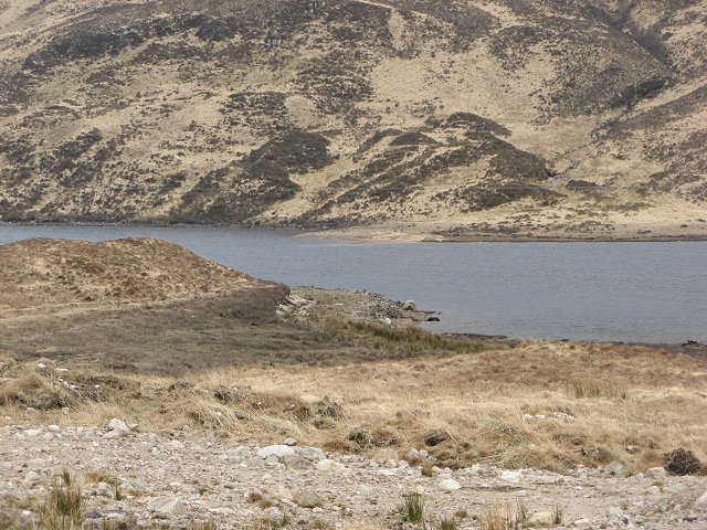
English: Loch Uisge Loch Uisge has been dammed for hydro electricity. The dark vegetation is the ground that is below the loch at its new level. Soon this will be scoured and be just a rocky lake bed.
The road used to run along the shore of the loch which is at its natural level here. The old road is just visible. The replacement is also single track with passing places. |
| Date | |
| Source | From geograph.org.uk |
| Author | Richard Webb |
| Attribution (required by the license) | Richard Webb / Loch Uisge / |
| Camera location | | View this and other nearby images on: OpenStreetMap |
|---|
_heading:180.00&language=en)
| Object location | | View this and other nearby images on: OpenStreetMap |
|---|
_heading:180.00&language=en)
Licensing
[edit]

|
This image was taken from the Geograph project collection. See this photograph's page on the Geograph website for the photographer's contact details. The copyright on this image is owned by Richard Webb and is licensed for reuse under the Creative Commons Attribution-ShareAlike 2.0 license.
|
This file is licensed under the Creative Commons Attribution-Share Alike 2.0 Generic license.
Attribution: Richard Webb
- You are free:
- to share – to copy, distribute and transmit the work
- to remix – to adapt the work
- Under the following conditions:
- attribution – You must give appropriate credit, provide a link to the license, and indicate if changes were made. You may do so in any reasonable manner, but not in any way that suggests the licensor endorses you or your use.
- share alike – If you remix, transform, or build upon the material, you must distribute your contributions under the same or compatible license as the original.
File history
Click on a date/time to view the file as it appeared at that time.
| Date/Time | Thumbnail | Dimensions | User | Comment | |
|---|---|---|---|---|---|
| current | 11:48, 4 February 2011 | | 640 × 480 (115 KB) | GeographBot (talk | contribs) | == {{int:filedesc}} == {{Information |description={{en|1=Loch Uisge Loch Uisge has been dammed for hydro electricity. The dark vegetation is the ground that is below the loch at its new level. Soon this will be scoured and be just a rocky lake bed. The |
You cannot overwrite this file.
File usage on Commons
There are no pages that use this file.