File:Loch Leven station site geograph-3758755-by-Ben-Brooksbank.jpg
Jump to navigation
Jump to search

Size of this preview: 800 × 506 pixels. Other resolutions: 320 × 203 pixels | 640 × 405 pixels | 1,024 × 648 pixels | 1,280 × 810 pixels | 2,395 × 1,516 pixels.
Original file (2,395 × 1,516 pixels, file size: 3.2 MB, MIME type: image/jpeg)
Captions
Captions
Add a one-line explanation of what this file represents
Summary
[edit]
| Description |
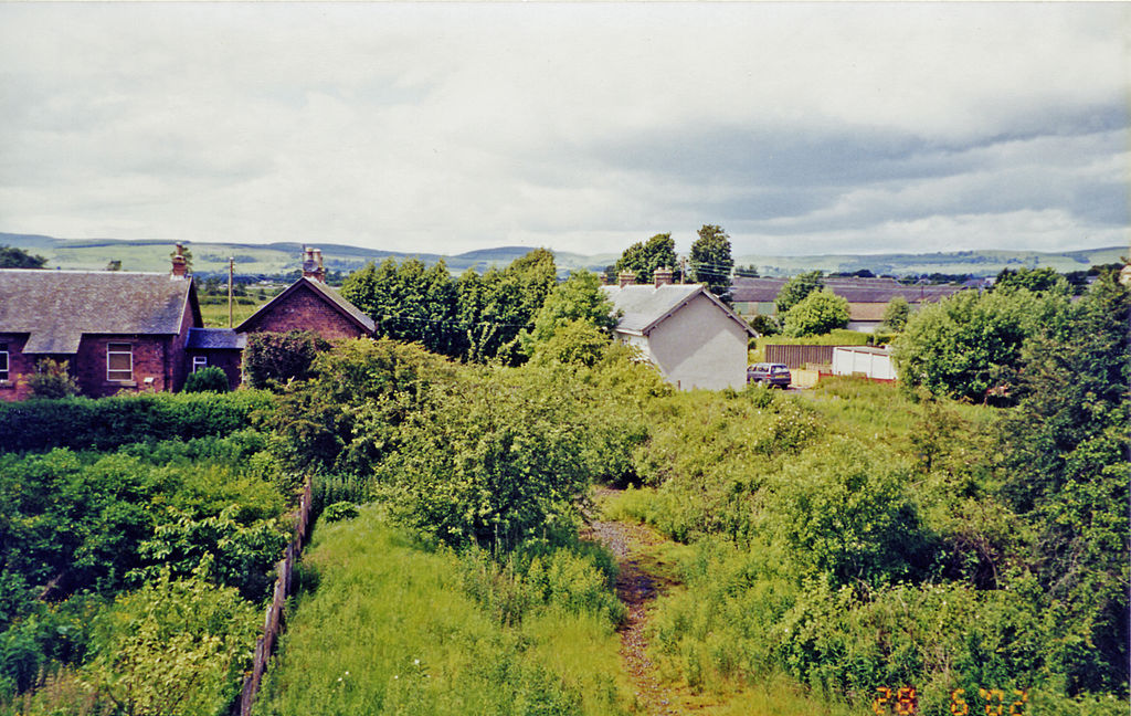
English: Kinross: site of former Loch Leven station, 2002. View NW from a surviving bridge, towards Kinross Junction - Milnathort - Mawcarse Junction, Bridge of Earn and Perth: ex-NBR Edinburgh/Glasgow - Forth Bridge - Dunfermline - Cowdenbeath - Perth main line! The station had been closed to passengers since 1/9/21, to goods since 29/3/65. The main line to Perth was abandoned from 5/1/70 Cowdenbeath - Kelty and Milnathort - Bridge of Earn, Kelty - Milnathort from 4/5/70. Since then Perth has had to be reached by a roundabout route via Thornton Junction (now Glenrothes), Ladyburn and Newburgh. Meanwhile the M90 motorway has been built, much of it along the course of the former main line to Perth. The motorway is not quite visible in the photograph but is just behind the houses. On the skyline are the Ochil Hills, including Sludgie Hill (1,354 ft.) and Dochrie Hill (1,194 ft.). Loch Leven itself stretches behind the camera. |
| Date | |
| Source | From geograph.org.uk |
| Author | Ben Brooksbank |
| Permission (Reusing this file) |
Creative Commons Attribution Share-alike license 2.0 |
| Attribution (required by the license) | Ben Brooksbank / Kinross: site of former Loch Leven station, 2002 / |
| Camera location | | View this and other nearby images on: OpenStreetMap |
|---|
Licensing
[edit]

|
This image was taken from the Geograph project collection. See this photograph's page on the Geograph website for the photographer's contact details. The copyright on this image is owned by Ben Brooksbank and is licensed for reuse under the Creative Commons Attribution-ShareAlike 2.0 license.
|
This file is licensed under the Creative Commons Attribution-Share Alike 2.0 Generic license.
Attribution: Ben Brooksbank
- You are free:
- to share – to copy, distribute and transmit the work
- to remix – to adapt the work
- Under the following conditions:
- attribution – You must give appropriate credit, provide a link to the license, and indicate if changes were made. You may do so in any reasonable manner, but not in any way that suggests the licensor endorses you or your use.
- share alike – If you remix, transform, or build upon the material, you must distribute your contributions under the same or compatible license as the original.
File history
Click on a date/time to view the file as it appeared at that time.
| Date/Time | Thumbnail | Dimensions | User | Comment | |
|---|---|---|---|---|---|
| current | 15:02, 29 December 2013 | | 2,395 × 1,516 (3.2 MB) | Chevin (talk | contribs) | == {{int:filedesc}} == {{Information |Description={{en|1='''Kinross: site of former Loch Leven station, 2002.'''<br/> View NW from a surviving bridge, towards Kinross Junction - Milnathort - Mawcarse Junction, Bridge of Earn and Perth: ex-NBR Edinburgh... |
You cannot overwrite this file.
File usage on Commons
The following page uses this file:
File usage on other wikis
The following other wikis use this file:
- Usage on en.wikipedia.org
- Usage on www.wikidata.org