File:Locator map of the 4e circonscription de la Vendée (since 1988).svg
Jump to navigation
Jump to search

Size of this PNG preview of this SVG file: 777 × 497 pixels. Other resolutions: 320 × 205 pixels | 640 × 409 pixels | 1,024 × 655 pixels | 1,280 × 819 pixels | 2,560 × 1,637 pixels.
Original file (SVG file, nominally 777 × 497 pixels, file size: 21 KB)
Captions
Captions
Add a one-line explanation of what this file represents
Summary
[edit].svg&action=edit§ion=1)
| Description |
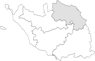
Français : Carte de la quatrième circonscription législative de la Vendée depuis 1988. |
| Date | |
| Source | Own work |
| Author |
Ce fichier est une réalisation d’Éduarel. En cas de réutilisation du fichier, il est vivement recommandé d’insérer la ligne suivante : © « Dénomination de l’illustration », Éduarel, Wikimedia Commons, Si ce fichier a été repris en dehors d’un projet de la Wikimedia Foundation, Inc., merci de l’indiquer. |
| Permission (Reusing this file) |
I, the copyright holder of this work, hereby publish it under the following license: This file is licensed under the Creative Commons Attribution-Share Alike 3.0 Unported license.
|
File history
Click on a date/time to view the file as it appeared at that time.
| Date/Time | Thumbnail | Dimensions | User | Comment | |
|---|---|---|---|---|---|
| current | 07:47, 30 April 2017 | | 777 × 497 (21 KB) | Éduarel (talk | contribs) | Ajustement |
| 18:48, 22 January 2016 |  | 854 × 547 (21 KB) | Éduarel (talk | contribs) | Sans les communes | |
| 18:27, 22 January 2016 |  | 854 × 547 (181 KB) | Éduarel (talk | contribs) | Carte avec les communes | |
| 10:42, 7 May 2015 |  | 3,465 × 2,245 (54 KB) | Éduarel (talk | contribs) | User created page with UploadWizard |
You cannot overwrite this file.
File usage on Commons
There are no pages that use this file.
File usage on other wikis
The following other wikis use this file:
- Usage on fr.wikipedia.org
.svg&oldid=507836354)