File:Location of Bolaven Plateau on Indochina topographic map.png
Jump to navigation
Jump to search

Size of this preview: 415 × 599 pixels. Other resolutions: 166 × 240 pixels | 332 × 480 pixels | 532 × 768 pixels | 709 × 1,024 pixels | 1,687 × 2,436 pixels.
Original file (1,687 × 2,436 pixels, file size: 4 MB, MIME type: image/png)
Captions
Captions
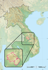
The Bolaven Plateau on the 1900-1945 Indochina topographic map.
Summary
[edit]
| Description |
Français : Le plateau des Bolovens sur la carte topographique de l'Indochine entre 1900 et 1945.
English: The Bolaven Plateau on the 1900-1945 Indochina topographic map. |
| Date | |
| Source | Own work |
| Author | PBrieux |
Licensing
[edit]
I, the copyright holder of this work, hereby publish it under the following license:
This file is licensed under the Creative Commons Attribution-Share Alike 4.0 International license.
- You are free:
- to share – to copy, distribute and transmit the work
- to remix – to adapt the work
- Under the following conditions:
- attribution – You must give appropriate credit, provide a link to the license, and indicate if changes were made. You may do so in any reasonable manner, but not in any way that suggests the licensor endorses you or your use.
- share alike – If you remix, transform, or build upon the material, you must distribute your contributions under the same or compatible license as the original.
File history
Click on a date/time to view the file as it appeared at that time.
| Date/Time | Thumbnail | Dimensions | User | Comment | |
|---|---|---|---|---|---|
| current | 16:14, 21 April 2020 | | 1,687 × 2,436 (4 MB) | PBrieux (talk | contribs) | Uploaded own work with UploadWizard |
You cannot overwrite this file.
File usage on Commons
There are no pages that use this file.
File usage on other wikis
The following other wikis use this file:
- Usage on fr.wikipedia.org