File:Location map Tlemcen.png
Jump to navigation
Jump to search

Size of this preview: 800 × 434 pixels. Other resolutions: 320 × 174 pixels | 640 × 347 pixels | 1,024 × 556 pixels | 1,535 × 833 pixels.
Original file (1,535 × 833 pixels, file size: 402 KB, MIME type: image/png)
Captions
Captions
Add a one-line explanation of what this file represents
Summary
[edit]
| Description |
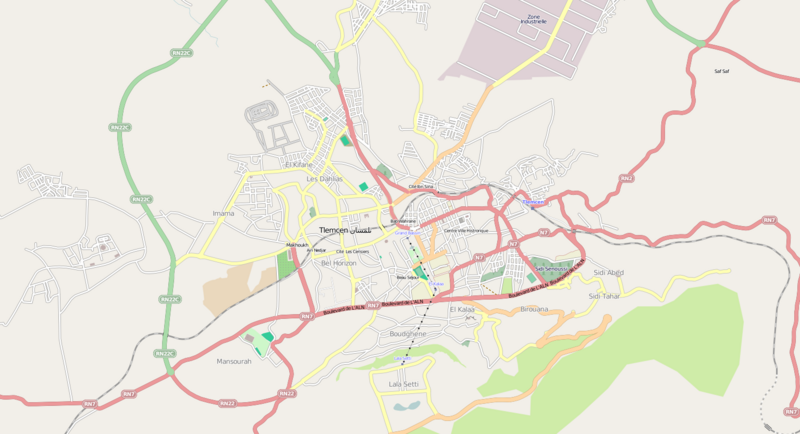
English: Map of Tlemcen, Algeria
Geographic limits of the map:
|
| Source | OpenStreetMap |
| Author | OpenStreetMap |
| Permission (Reusing this file) |
This file is licensed under the Creative Commons Attribution-Share Alike 2.0 Generic license.
|
File history
Click on a date/time to view the file as it appeared at that time.
| Date/Time | Thumbnail | Dimensions | User | Comment | |
|---|---|---|---|---|---|
| current | 12:14, 26 September 2011 | | 1,535 × 833 (402 KB) | وهراني (talk | contribs) | {{Information |Description ={{en|1=Map of Tlemcen, Algeria Geographic limits of the map: * N: 34.9077° * S: 34.8604° * W:-1.3718° * E:-1.2656° {{CC-BY-SA 2.0}}}} |Source =OpenStreetMap |Author =OpenStreetMap |Date = |
| 12:10, 26 September 2011 |  | 1,535 × 833 (402 KB) | وهراني (talk | contribs) | {{Information |Description ={{en|1={{en|1=Map of Tlemcen, Algeria Geographic limits of the map: * N: 34.9077° * S: 34.8604° * W:-1.3718° * E:-1.2656° {{CC-BY-SA 2.0}}}}}} |Source =OpenStreetMap |Author =OpenStreetMap |Date |
You cannot overwrite this file.
File usage on Commons
There are no pages that use this file.
File usage on other wikis
The following other wikis use this file:
- Usage on ar.wikipedia.org
- Usage on da.wikipedia.org
- Usage on fr.wikipedia.org
- Usage on he.wikipedia.org
- Usage on incubator.wikimedia.org