File:Llywernog Silver Lead Mine Museum- waterwheel naves (geograph 5725671).jpg
Jump to navigation
Jump to search

Size of this preview: 800 × 539 pixels. Other resolutions: 320 × 215 pixels | 640 × 431 pixels | 1,024 × 689 pixels | 1,280 × 862 pixels | 1,600 × 1,077 pixels.
Original file (1,600 × 1,077 pixels, file size: 888 KB, MIME type: image/jpeg)
Captions
Captions
Add a one-line explanation of what this file represents
Summary
[edit].jpg&action=edit§ion=1)
| Description |
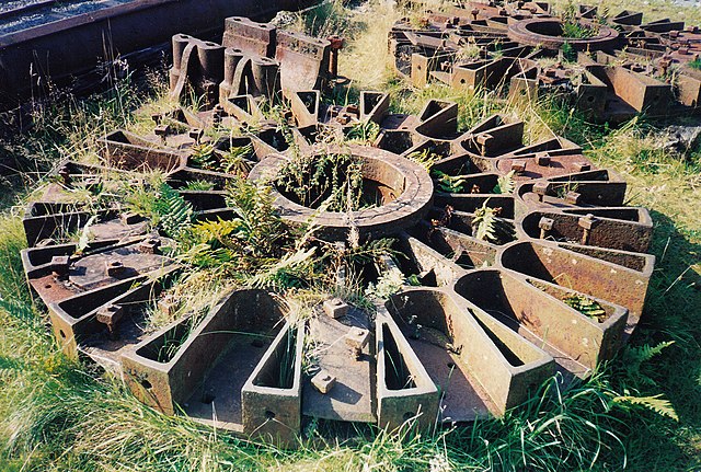
English: Llywernog Silver Lead Mine Museum: waterwheel naves. The naves of a 50ft diameter waterwheel, cast by Leigh and Gilbert Howell of the Hawarden Iron Works, Flintshire, in 1865. The wheel was used by the Snaefell Mining Co in the Isle of Man until 1910 when it was dismantled and transferred to Cornwall for use by a china clay works. It was saved in 1971 and in 1976 taken to Llywernog. Later the wheel's components were moved again and restored in the Isle of Man. It now works in Laxey Valley Gardens |
| Date | |
| Source | From geograph.org.uk |
| Author | Martin Bodman |
| Permission (Reusing this file) |
Creative Commons Attribution Share-alike license 2.0 |
| Attribution (required by the license) | Martin Bodman / Llywernog Silver Lead Mine Museum: waterwheel naves / |
| Camera location | | View this and other nearby images on: OpenStreetMap |
|---|
.jpg¶ms=052.411543_N_-003.865487_E_globe:Earth_type:camera_source:geograph-osgb36(SN73218092)_heading:270.00&language=en)
| Object location | | View this and other nearby images on: OpenStreetMap |
|---|
.jpg¶ms=052.411540_N_-003.865630_E_globe:Earth_class:object_type:object_source:geograph-osgb36(SN73208092)_heading:270.00&language=en)
Licensing
[edit].jpg&action=edit§ion=2)

|
This image was taken from the Geograph project collection. See this photograph's page on the Geograph website for the photographer's contact details. The copyright on this image is owned by Martin Bodman and is licensed for reuse under the Creative Commons Attribution-ShareAlike 2.0 license.
|
This file is licensed under the Creative Commons Attribution-Share Alike 2.0 Generic license.
Attribution: Martin Bodman
- You are free:
- to share – to copy, distribute and transmit the work
- to remix – to adapt the work
- Under the following conditions:
- attribution – You must give appropriate credit, provide a link to the license, and indicate if changes were made. You may do so in any reasonable manner, but not in any way that suggests the licensor endorses you or your use.
- share alike – If you remix, transform, or build upon the material, you must distribute your contributions under the same or compatible license as the original.
File history
Click on a date/time to view the file as it appeared at that time.
| Date/Time | Thumbnail | Dimensions | User | Comment | |
|---|---|---|---|---|---|
| current | 15:58, 4 April 2018 | | 1,600 × 1,077 (888 KB) | Chris j wood (talk | contribs) | Transferred from geograph.co.uk using [https://tools.wmflabs.org/geograph2commons/ geograph2commons] |
You cannot overwrite this file.
File usage on Commons
There are no pages that use this file.
.jpg&oldid=933790768)