File:Little Thompson River Bridge.JPG
Jump to navigation
Jump to search

Size of this preview: 800 × 441 pixels. Other resolutions: 320 × 176 pixels | 640 × 353 pixels | 1,024 × 564 pixels | 1,280 × 705 pixels | 2,560 × 1,411 pixels | 4,057 × 2,236 pixels.
Original file (4,057 × 2,236 pixels, file size: 7.21 MB, MIME type: image/jpeg)
Captions
Captions
Add a one-line explanation of what this file represents
|
This is an image of a place or building that is listed on the National Register of Historic Places in the United States of America. Its reference number is 02001129. |
Summary
[edit]
| Description |
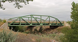
English: The Little Thompson River Bridge, located at Interstate 25 service road at milepost 249.90, near Berthoud, Colorado. The bridge is listed on the National Register of Historic Places. |
| Date | Taken on 16 August 2012 |
| Source | Own work |
| Author | Jeffrey Beall |
| Camera location | | View this and other nearby images on: OpenStreetMap |
|---|

|
This image was uploaded as part of Wiki Loves Monuments 2012.
|
 |
Licensing
[edit]
I, the copyright holder of this work, hereby publish it under the following license:
This file is licensed under the Creative Commons Attribution-Share Alike 3.0 Unported license.
- You are free:
- to share – to copy, distribute and transmit the work
- to remix – to adapt the work
- Under the following conditions:
- attribution – You must give appropriate credit, provide a link to the license, and indicate if changes were made. You may do so in any reasonable manner, but not in any way that suggests the licensor endorses you or your use.
- share alike – If you remix, transform, or build upon the material, you must distribute your contributions under the same or compatible license as the original.
File history
Click on a date/time to view the file as it appeared at that time.
| Date/Time | Thumbnail | Dimensions | User | Comment | |
|---|---|---|---|---|---|
| current | 14:44, 1 September 2012 | | 4,057 × 2,236 (7.21 MB) | Jeffrey Beall (talk | contribs) | {{Information |Description ={{en|1=The Little Thompson River Bridge, located at Interstate 25 service road at milepost 249.90, near Berthoud, Colorado. The bridge is listed on the National Register of Historic Places. }} |Source ={{own}} |Au... |
You cannot overwrite this file.
File usage on Commons
There are no pages that use this file.
File usage on other wikis
The following other wikis use this file:
- Usage on en.wikipedia.org
- Usage on www.wikidata.org
Metadata
Categories:
- National Register of Historic Places in Weld County, Colorado
- Bridges on the National Register of Historic Places in Colorado
- Bridges over rivers in Colorado
- Road bridges in Colorado
- Pony truss bridges in Colorado
- 2012 in Colorado
- U.S. Route 87 in Colorado
- U.S. Highway bridges
- Frontage roads in Colorado
- Green bridges in the United States
- Built in Colorado in 1938
- 1930s bridges in Colorado
- Replaced bridges in Colorado