File:Lithuania Territorial Extension 1430.svg
Jump to navigation
Jump to search

Size of this PNG preview of this SVG file: 735 × 333 pixels. Other resolutions: 320 × 145 pixels | 640 × 290 pixels | 1,024 × 464 pixels | 1,280 × 580 pixels | 2,560 × 1,160 pixels.
Original file (SVG file, nominally 735 × 333 pixels, file size: 534 KB)
Captions
Captions
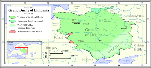
Territory of the Grand Duchy of Lithuania in 1430.
Summary
[edit]
| Description |
English: Own work:
Coastline, rivers, inset map and gridline were Made with Natural Earth. Borders were derived from Вялікі гістарычны атлас Беларусі. (Great Historical Atlas of Belarus, Vol.I (2009). P.68-69. Further info on the title can be found on Worldcat: https://search.worldcat.org/title/780922940 Lastly, WGS 84 is the projection used for this map. |
| Date | |
| Source | Own work |
| Author | HetmanTheResearcher |
Licensing
[edit]
I, the copyright holder of this work, hereby publish it under the following license:
This file is licensed under the Creative Commons Attribution 4.0 International license.
- You are free:
- to share – to copy, distribute and transmit the work
- to remix – to adapt the work
- Under the following conditions:
- attribution – You must give appropriate credit, provide a link to the license, and indicate if changes were made. You may do so in any reasonable manner, but not in any way that suggests the licensor endorses you or your use.
File history
Click on a date/time to view the file as it appeared at that time.
| Date/Time | Thumbnail | Dimensions | User | Comment | |
|---|---|---|---|---|---|
| current | 20:11, 29 January 2024 | | 735 × 333 (534 KB) | HetmanTheResearcher (talk | contribs) | Minor touch ups |
| 20:08, 29 January 2024 |  | 735 × 333 (534 KB) | HetmanTheResearcher (talk | contribs) | Attempt #2 to fix font problem. | |
| 19:19, 29 January 2024 |  | 735 × 333 (502 KB) | HetmanTheResearcher (talk | contribs) | Attempt #1 to fix font problem. | |
| 19:15, 29 January 2024 |  | 735 × 333 (500 KB) | HetmanTheResearcher (talk | contribs) | Uploaded own work with UploadWizard |
You cannot overwrite this file.
File usage on Commons
There are no pages that use this file.
File usage on other wikis
The following other wikis use this file:
- Usage on en.wikipedia.org
- Usage on ms.wikipedia.org