File:LithuaniaPhysicalMap-en.png
Jump to navigation
Jump to search

Size of this preview: 800 × 560 pixels. Other resolutions: 320 × 224 pixels | 640 × 448 pixels | 1,024 × 717 pixels | 1,280 × 896 pixels | 2,361 × 1,653 pixels.
Original file (2,361 × 1,653 pixels, file size: 2.43 MB, MIME type: image/png)
Captions
Captions
Add a one-line explanation of what this file represents
Summary
[edit]
| Description |
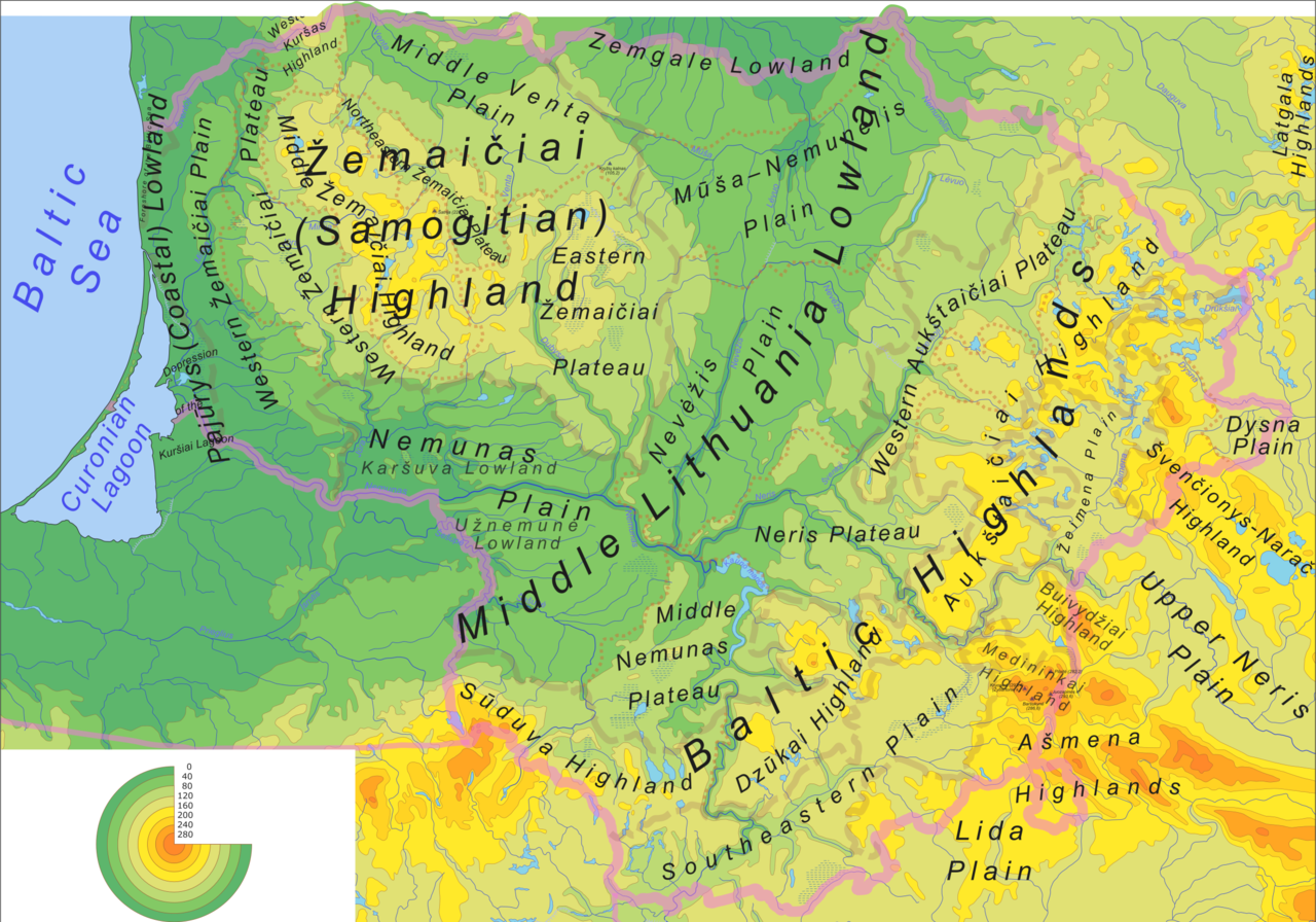
Physical map and geomorphological subdivision of the Lithuania. Source file - Image:LithuaniaPhysicalMap-en.svg |
| Date | 11 February 2006 (original upload date) |
| Source | No machine-readable source provided. Own work assumed (based on copyright claims). |
| Author | No machine-readable author provided. Knutux assumed (based on copyright claims). |
Licensing
[edit]
I, the copyright holder of this work, hereby publish it under the following licenses:

|
Permission is granted to copy, distribute and/or modify this document under the terms of the GNU Free Documentation License, Version 1.2 or any later version published by the Free Software Foundation; with no Invariant Sections, no Front-Cover Texts, and no Back-Cover Texts. A copy of the license is included in the section entitled GNU Free Documentation License. |
| This file is licensed under the Creative Commons Attribution-Share Alike 3.0 Unported license. | ||
| ||
| This licensing tag was added to this file as part of the GFDL licensing update. |
This file is licensed under the Creative Commons Attribution-Share Alike 2.5 Generic, 2.0 Generic and 1.0 Generic license.
- You are free:
- to share – to copy, distribute and transmit the work
- to remix – to adapt the work
- Under the following conditions:
- attribution – You must give appropriate credit, provide a link to the license, and indicate if changes were made. You may do so in any reasonable manner, but not in any way that suggests the licensor endorses you or your use.
- share alike – If you remix, transform, or build upon the material, you must distribute your contributions under the same or compatible license as the original.
You may select the license of your choice.
File history
Click on a date/time to view the file as it appeared at that time.
| Date/Time | Thumbnail | Dimensions | User | Comment | |
|---|---|---|---|---|---|
| current | 06:27, 14 February 2006 | | 2,361 × 1,653 (2.43 MB) | Knutux (talk | contribs) | some more minor adjustments |
| 07:09, 13 February 2006 |  | 2,361 × 1,653 (2.41 MB) | Knutux (talk | contribs) | new version (updated labels by user comments) | |
| 06:02, 11 February 2006 |  | 2,361 × 1,653 (2.28 MB) | Knutux (talk | contribs) | Physical map and geomorphological subdivision of the Lithuania. Source file - Image:LithuaniaPhysicalMap-en.svg category:Maps of Lithuania |
You cannot overwrite this file.
File usage on Commons
The following page uses this file:
File usage on other wikis
The following other wikis use this file:
- Usage on ar.wikipedia.org
- Usage on en.wikipedia.org
- Usage on ff.wikipedia.org
- Usage on id.wikipedia.org
- Usage on io.wikipedia.org
- Usage on is.wikipedia.org
- Usage on lt.wikipedia.org
- Usage on mt.wikipedia.org
- Usage on ps.wikipedia.org
- Usage on sd.wikipedia.org
- Usage on sl.wikipedia.org
- Usage on trv.wikipedia.org
- Usage on zh.wikipedia.org