File:Lissel Verkehrsplan Leipzig 1913.jpg
Jump to navigation
Jump to search

Size of this preview: 782 × 600 pixels. Other resolutions: 313 × 240 pixels | 626 × 480 pixels | 1,001 × 768 pixels | 1,280 × 982 pixels | 2,560 × 1,964 pixels | 10,820 × 8,300 pixels.
Original file (10,820 × 8,300 pixels, file size: 22.22 MB, MIME type: image/jpeg)
Captions
Captions
Add a one-line explanation of what this file represents
| Warning | The original file is very high-resolution. It might not load properly or could cause your browser to freeze when opened at full size. |
|---|
Summary
[edit]
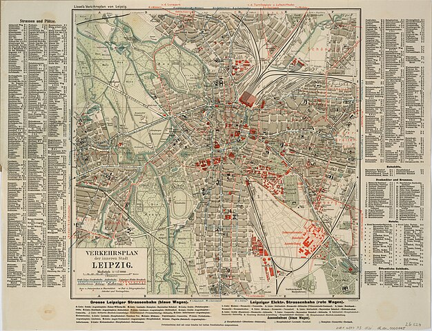
| Title |
VERKEHRSPLAN der inneren Stadt LEIPZIG |
| Description |
Deutsch: Stadtplan von Leipzig mit Straßenverzeichnis, besonders verzeichnet:
|
| Date | [1913] |
| Source | Deutsche Fotothek |
| Creator |
[Paul Lissel] |
| Geotemporal data | |
| Map location | Leipzig |
| Scale | 1:17,000 |
| Heading |
 |
| Georeferencing | If inappropriate please set warp_status = skip to hide. |
| Bibliographic data | |
| Language | German |
| Archival data | |
| Dimensions | height: 35 cm (13.7 in); width: 35 cm (13.7 in) |
Licensing
[edit]
|
This work is in the public domain in its country of origin and other countries and areas where the copyright term is the author's life plus 70 years or fewer. This work is in the public domain in the United States because it was published (or registered with the U.S. Copyright Office) before January 1, 1929. | |
| This file has been identified as being free of known restrictions under copyright law, including all related and neighboring rights. | |
File history
Click on a date/time to view the file as it appeared at that time.
| Date/Time | Thumbnail | Dimensions | User | Comment | |
|---|---|---|---|---|---|
| current | 00:08, 26 November 2020 | | 10,820 × 8,300 (22.22 MB) | Mapmarks (talk | contribs) | Reverted to version as of 19:53, 27 October 2020 (UTC) |
| 22:21, 29 October 2020 |  | 10,820 × 8,300 (23.48 MB) | Mapmarks (talk | contribs) | adjusted color levels | |
| 19:53, 27 October 2020 |  | 10,820 × 8,300 (22.22 MB) | Mapmarks (talk | contribs) | {{LargeImage}} == {{int:filedesc}} == {{map |title=VERKEHRSPLAN der inneren Stadt LEIPZIG |description={{de|1=Stadtplan von Leipzig mit Straßenverzeichnis, besonders verzeichnet: * Straßenbahn- und Buslinien * Reit- und Radfahrwege * Sanitäts-, Rats- und Polizeiwachen * Post- und Telegraphenämter * Schreber- und Vereinsgärten }} |author=[Paul Lissel] |date=[1913] |source=[http://www.deutschefotothek.de/documents/obj/70401831 Deutsche Fotothek] |location=Leipzig |scale=17000 |heading=0 |latit... |
You cannot overwrite this file.
File usage on Commons
The following 6 pages use this file:
- User:Chumwa/OgreBot/Public transport information/2020 November 21-30
- User:Chumwa/OgreBot/Public transport information/2020 October 21-31
- User:Chumwa/OgreBot/Transport Maps/2020 November 21-30
- User:Chumwa/OgreBot/Transport Maps/2020 October 21-31
- User:Roy17/Leipzig/2020 November
- User:Roy17/Leipzig/2020 October