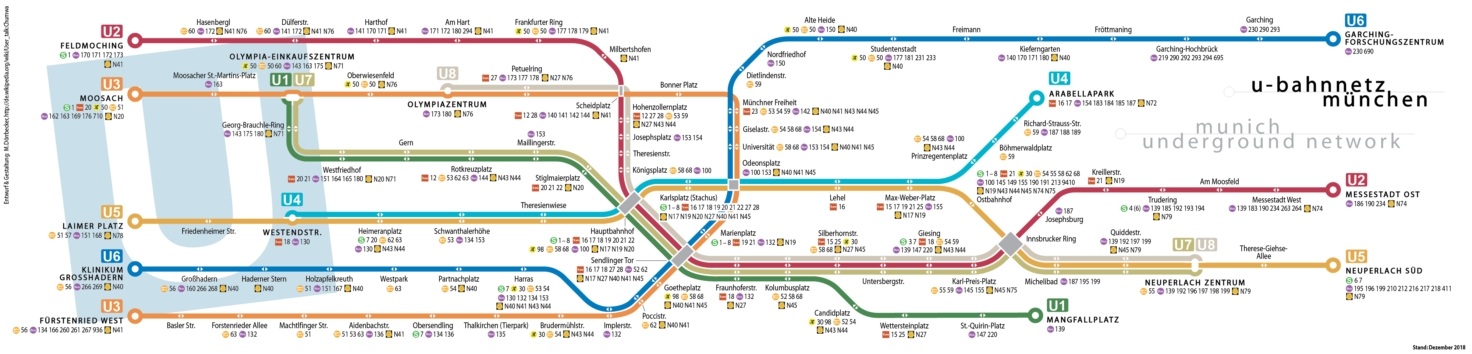
File:Linienband U-Bahn München.png
Jump to navigation
Jump to search
Size of this preview: 800 × 193 pixels. Other resolutions: 320 × 77 pixels | 640 × 154 pixels | 1,024 × 247 pixels | 1,280 × 308 pixels | 4,831 × 1,164 pixels.
Original file (4,831 × 1,164 pixels, file size: 612 KB, MIME type: image/png)
Captions
Captions
Add a one-line explanation of what this file represents

|
This transport map image could be re-created using vector graphics as an SVG file. This has several advantages; see Commons:Media for cleanup for more information. If an SVG form of this image is available, please upload it and afterwards replace this template with
{{vector version available|new image name}}.
It is recommended to name the SVG file “Linienband U-Bahn München.svg”—then the template Vector version available (or Vva) does not need the new image name parameter. |
| Description |
|
| Date | see file history |
| Source | Self made (logos used: S-Bahn, U-Bahn, Tram, Bus; some are modified) |
| Author | Maximilian Dörrbecker (Chumwa) |
| Permission (Reusing this file) |
I, the copyright holder of this work, hereby publish it under the following license: This file is licensed under the Creative Commons Attribution-Share Alike 2.5 Generic license.
Sie dürfen das Bild zu den folgenden Bedingungen nutzen:
|
| Other versions |
Weitere Münchner ÖPNV-Pläne:
|


File history
Click on a date/time to view the file as it appeared at that time.
| Date/Time | Thumbnail | Dimensions | User | Comment | |
|---|---|---|---|---|---|
| current | 16:46, 29 December 2018 | 4,831 × 1,164 (612 KB) | Chumwa (talk | contribs) | Fahrplanwechsel Dez. 2018 | |
| 05:57, 3 March 2017 | 4,831 × 1,164 (593 KB) | Chumwa (talk | contribs) | Korrekturen an den Anschlusslinien in Neuperlach Süd | ||
| 22:03, 1 March 2017 | 4,831 × 1,164 (593 KB) | Chumwa (talk | contribs) | diverse Korrekturen | ||
| 15:14, 23 December 2016 | 4,831 × 1,164 (587 KB) | Chumwa (talk | contribs) | Fahrplanwechsel Dezember 2016 | ||
| 08:01, 11 January 2014 | 4,831 × 1,164 (578 KB) | Chumwa (talk | contribs) | diverse Aktualisierungen bei den Busanschlüssen | ||
| 19:15, 15 December 2013 | 4,831 × 1,164 (341 KB) | Chumwa (talk | contribs) | |||
| 22:53, 30 January 2012 | 4,831 × 1,164 (339 KB) | Chumwa (talk | contribs) | diverse Fehler und veraltete Informationen bei den Anschlusslinien bereinigt | ||
| 17:41, 13 December 2011 | 4,831 × 1,164 (330 KB) | Chumwa (talk | contribs) | Berandung der U7 entfernt | ||
| 17:37, 13 December 2011 | 4,831 × 1,164 (331 KB) | Chumwa (talk | contribs) | Farbton der U7 korrigiert | ||
| 08:35, 10 December 2011 | 4,831 × 1,164 (331 KB) | Chumwa (talk | contribs) | Fahrplanwechsel Dez. 2011 |
You cannot overwrite this file.
File usage on Commons
The following 83 pages use this file:
- München
- München U-Bahn
- Top 200 transport map images that should use vector graphics
- User:Chumwa/Gallery
- User:Chumwa/OgreBot/München/2016 December 21-31
- User:Chumwa/OgreBot/München/2017 March 1-10
- User:Chumwa/OgreBot/München/2018 December 21-31
- User:Chumwa/OgreBot/Potential transport maps/2016 December 21-31
- User:Chumwa/OgreBot/Potential transport maps/2017 March 1-10
- User:Chumwa/OgreBot/Potential transport maps/2018 December 21-31
- User:Chumwa/OgreBot/Public transport information/2016 December 21-31
- User:Chumwa/OgreBot/Public transport information/2017 March 1-10
- User:Chumwa/OgreBot/Public transport information/2018 December 21-31
- User:Chumwa/OgreBot/Transport Maps/2016 December 21-31
- User:Chumwa/OgreBot/Transport Maps/2017 March 1-10
- User:Chumwa/OgreBot/Transport Maps/2018 December 21-31
- User:Chumwa/OgreBot/Travel and communication maps/2016 December 21-31
- User:Chumwa/OgreBot/Travel and communication maps/2017 March 1-10
- User:Chumwa/OgreBot/Travel and communication maps/2018 December 21-31
- User:Chumwa/OtherVersions - Karten München
- User:Chumwa/OtherVersions - ÖPNV-Karten München
- File:Administrative boundaries of the borough of Solln in Munich.png
- File:Basiskarte Kiel.png
- File:Gleis 93.jpg
- File:Gleis 96.jpg
- File:Gleis 97b.jpg
- File:Karte Flaucher München.png
- File:Karte München - WirtshausWiesn 2020.png
- File:Karte München Basiskarte.jpg
- File:Karte München Basiskarte.png
- File:Karte München Landnutzung.png
- File:Karte München Schwarzplan.png
- File:Karte München ÖPNV.png
- File:Karte München Übersichtsplan.png
- File:Karte Streetlife München.png
- File:Karte Viktualienmarkt München.png
- File:Karte der Burgfrieden von München.png
- File:Karte der Denkmalschutzensembles in München.jpg
- File:Karte der Gemarkungen in München.png
- File:Karte der Gemarkungen und Stadtbezirke in München.png
- File:Karte der Ortsbezeichnungen in München.png
- File:Karte der Parkstadt Bogenhausen in München.png
- File:Karte der S-Bahn München.png
- File:Karte der Stadtbezirke in München.png
- File:Karte der Stadtbezirke in München in der bis 1992 gültigen Gliederung.png
- File:Karte der Stadtbezirksteile in München.png
- File:Karte der geplanten U9-Spange der U-Bahn München.png
- File:Linienband U-Bahn München.png
- File:Metrobusnetzplan München.png
- File:MuenchenSBahnMitSuedring.png
- File:MuenchenSBahnMitZweitemTunnel.png
- File:München - Basiskarte farbig.pdf
- File:München - Basiskarte farbig.png
- File:München - Basiskarte farbig - mit Nachbargemeinden.jpg
- File:München - Basiskarte farbig - mit Nachbargemeinden.png
- File:München - Basiskarte grau.pdf
- File:München - Basiskarte grau.png
- File:München - Stadtbezirke (Karte).png
- File:Positionskarte München.png
- File:Schnellbahnplan München.png
- File:SchnellbahnschemaplanMuenchenTopographisch2006.png
- File:SchnellbahnschemaplanMuenchenTopographisch2007.png
- File:Stadterweiterungen München.png
- File:StrassenbahnSchemaplanMuenchen1997.png
- File:StrassenbahnnetzMuenchen1964.jpg
- File:Straßenbahn-Linienplan München.png
- File:Straßenbahnnetzplan München.png
- File:Streckennetz der S-Bahn München.jpg
- File:U-Bahn-Plan München.png
- File:UBahnLinienbandMuenchen2006.png
- File:UBahnLinienbandMuenchen2007.png
- File:UBahnLinienbandMuenchen2008.png (file redirect)
- File:UBahnMuenchen Stammstrecke3.png
- File:UBahnSchemaplanMuenchenTopographisch2006.png
- File:UBahnSchemaplanMuenchenTopographisch2007.png
- File:UBahnSchemaplanMuenchenTopographisch2008.png
- File:VerkehrsnetzMuenchen2006.png
- File:VerkehrsnetzMuenchen2007.png
- File:VerkehrsnetzMünchen2005.png
- File:Verkehrsnetz München.png
- File:Verkehrsnetz München 2007.png
- File:Westpark München (Karte).png
- File:Westpark München zur IGA 1983 (Karte).png
.png)
.png)
.png)
File usage on other wikis
The following other wikis use this file:
- Usage on de.wikipedia.org
- Usage on es.wikipedia.org
- Usage on fr.wikipedia.org
- Usage on hu.wikipedia.org
- Usage on ko.wikipedia.org
- Usage on lb.wikipedia.org
- Usage on pl.wikipedia.org
- Usage on ru.wikipedia.org
- Usage on th.wikipedia.org
- Usage on www.wikidata.org
- Usage on zh.wikipedia.org