File:Linghai Jixian.png

Original file (1,818 × 1,530 pixels, file size: 4.16 MB, MIME type: image/png)
Captions
Captions

|
This economic map image could be re-created using vector graphics as an SVG file. This has several advantages; see Commons:Media for cleanup for more information. If an SVG form of this image is available, please upload it and afterwards replace this template with
{{vector version available|new image name}}.
It is recommended to name the SVG file “Linghai Jixian.svg”—then the template Vector version available (or Vva) does not need the new image name parameter. |
Summary
[edit]
| Description |
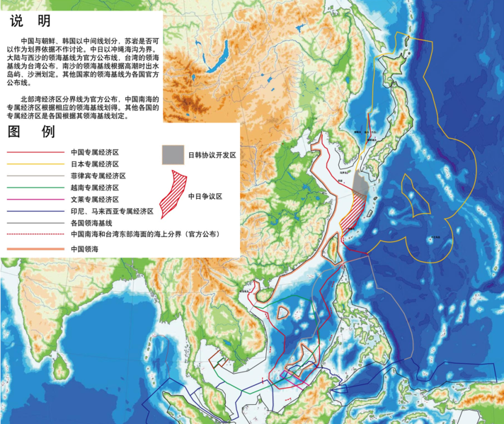
在不牵扯各国领陆、领空、底土纠纷,钓鱼台列岛、苏岩礁不作基点以及不谈台湾问题的前提下,标明: |
| Date | |
| Source |
s:zh:联合国海洋法公约 s:zh:中华人民共和国领海及毗连区法(“中华人民共和国领海的宽度从领海基线量起为十二海里”) s:zh:中华人民共和国政府关于中华人民共和国领海基线的声明 s:zh:中華民國八十八年二月十日行政院台八十八內字第〇六一六一號令公告 s:zh:中华人民共和国和越南社会主义共和国关于两国在北部湾领海、专属经济区和大陆架的划界协定 1982年11月12日越南社会主义共和国政府关于越南领海基线的声明 柬埔寨国务院关于柬埔寨人民共和国领海基线的法令 日本国平成8年第73号法令 大韩民国实行领海海域法的法令(第9162号总统令) 一则界定菲律宾领海基线的法令(共和国3046号/5446号法令) 文莱专属经济区 印度-印度尼西亚-泰国海洋边界/印度与缅甸的海洋边界 印度尼西亚与马来西亚的海洋边界 马来西亚的海洋边界 |
| Author | |
| Other versions |
Image:Bazlinio de Orienta Azio malplena.png Image:Baselines of Eastern Asia English.png |
写在图像 (Text on image)
[edit]
(用于搜索引擎,盲人屏幕阅读器,字体更改等) (For the purposes of search engines, screen readers for the blind, font changes, and etc.)
说明
[edit]
中国与朝鲜、韩国以中间线划分,苏岩是否可 以作为划界依据不作讨论。中日以冲绳海沟为界。大陆与西沙的领海基线为官方公布线,台湾的领海基线为台湾公布,南沙的领海基线根据高潮时出水岛屿、沙洲划定。其他国家的领海基线为各国官方 公布线。
北部湾经济区分界线为官方公布,中国南海的 专属经济区根据相应的领海基线划得。其他各国的 专属经济区是各国根据其领海基线划定。
图例
[edit]
中国领海 中国南海和台湾东部海面的海上分界(官方公布) 各国领海基线 印尼、马来西亚专属经济区 文莱专属经济区 越南专属经济区 菲律宾专属经济区 日本专属经济区 中国专属经济区 中日争议区 日韩协议开发区
Licensing
[edit]
I, the copyright holder of this work, hereby release it into the public domain. This applies worldwide. In case this is not legally possible: I grant anyone the right to use this work for any purpose, without any conditions, unless such conditions are required by law.
|
File history
Click on a date/time to view the file as it appeared at that time.
| Date/Time | Thumbnail | Dimensions | User | Comment | |
|---|---|---|---|---|---|
| current | 08:37, 22 February 2016 | | 1,818 × 1,530 (4.16 MB) | Cq521 (talk | contribs) | size |
| 23:00, 12 April 2008 |  | 1,818 × 2,331 (6.88 MB) | Shibo77 (talk | contribs) | ||
| 22:34, 12 April 2008 |  | 1,818 × 2,331 (6.88 MB) | Shibo77 (talk | contribs) | Eta sxangxo. | |
| 21:57, 12 April 2008 |  | 1,818 × 2,331 (6.88 MB) | Shibo77 (talk | contribs) | {{Information |Description= |Source= |Date= |Author= |Permission= |other_versions= }} |
You cannot overwrite this file.
File usage on Commons
There are no pages that use this file.
File usage on other wikis
The following other wikis use this file:
- Usage on wuu.wikipedia.org
- Usage on zh.wikipedia.org