File:Lindomekarta.png
Jump to navigation
Jump to search
No higher resolution available.
Lindomekarta.png (387 × 207 pixels, file size: 2 KB, MIME type: image/png)
Captions
Captions
Add a one-line explanation of what this file represents
Summary
[edit]
| Description |
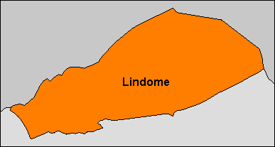
Svenska: Enkel gränskarta över Lindome (socken/församling/tidigare landskommun). Gränsdragningen är den nuvarande, efter senaste gränsjusteringen på 1950-talet. |
| Date | |
| Source | Own work |
| Author | Per A.J. Andersson |
In part based upon File:Hallands län 1952 Lindome.png.
Licensing
[edit]
I, the copyright holder of this work, hereby publish it under the following license:
This file is licensed under the Creative Commons Attribution-Share Alike 3.0 Unported license.
- You are free:
- to share – to copy, distribute and transmit the work
- to remix – to adapt the work
- Under the following conditions:
- attribution – You must give appropriate credit, provide a link to the license, and indicate if changes were made. You may do so in any reasonable manner, but not in any way that suggests the licensor endorses you or your use.
- share alike – If you remix, transform, or build upon the material, you must distribute your contributions under the same or compatible license as the original.
File history
Click on a date/time to view the file as it appeared at that time.
| Date/Time | Thumbnail | Dimensions | User | Comment | |
|---|---|---|---|---|---|
| current | 11:53, 5 January 2013 | | 387 × 207 (2 KB) | Paracel63 (talk | contribs) | Borders and greyscale around |
| 11:44, 5 January 2013 |  | 385 × 205 (2 KB) | Paracel63 (talk | contribs) | User created page with UploadWizard |
You cannot overwrite this file.
File usage on Commons
There are no pages that use this file.
File usage on other wikis
The following other wikis use this file:
- Usage on sv.wikipedia.org
- Rune Andréasson
- Göteborgsstolen
- Lindome
- Nordsjön, Härryda kommun
- Lindome församling
- Lindome GIF
- Kungsbackaån
- Sandsjöbacka naturreservat, Västra Götalands län
- Lindome kyrka
- IK Uven
- Fagareds ungdomshem
- Humlekärr
- Lindome landskommun
- Astrid Pettersson
- Flabäck
- Lindome socken
- Lindome Bouleklubb
- Mall:Lindome
- Möbeltillverkning i Lindome socken
- Skogtorpa
- Barnsjöområdet
- Östersjön (Landvetters socken, Västergötland)
- Abborrtjärnen (Lindome socken, Halland)
- Axlavad
- Dammtjärnen, Halland
- Fageredssjön
- Flaksjö
- Hålevatten
- Klavatjärnen, Halland
- Oxögat (Lindome socken, Halland)
- Kroksjön (Lindome socken, Halland)
- Lilla Hassungaredssjön
- Mellsjö
- Norra Barnsjön
- Ostjärnen, Halland
- Raneredstjärnen
- Ringtjärnen, Halland
- Råsjö
- Sagsjön, Halland
- Sandsjö, Halland
- Slättåstjärnen, Halland
- Småsjön, Halland
- Stora Hassungaredssjön
- Stora Hålevatten (Lindome socken, Halland)
- Stora Hällesåkertjärnen
- Stora Ötjärnen, Halland
- Södra Barnsjön
- Utesjö
- Västra Kniperedstjärnen
- Yxnavad
View more global usage of this file.