File:Lincoln Highway, Duncan, Nebraska marker from E.JPG
Jump to navigation
Jump to search

Size of this preview: 418 × 599 pixels. Other resolutions: 167 × 240 pixels | 335 × 480 pixels | 535 × 768 pixels | 1,237 × 1,774 pixels.
Original file (1,237 × 1,774 pixels, file size: 878 KB, MIME type: image/jpeg)
Captions
Captions
Add a one-line explanation of what this file represents
|
This is an image of a place or building that is listed on the National Register of Historic Places in the United States of America. Its reference number is 7000656. |
Summary
[edit]
| Description |
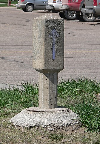
English: Lincoln Highway marker Duncan, Nebraska; seen from the east. The blue arrow on the marker points southwestward. The marker is part of the Lincoln Highway-Duncan West property, which is listed in the National Register of Historic Places. |
| Date | |
| Source | Own work |
| Author | Ammodramus |
| Object location | | View this and other nearby images on: OpenStreetMap |
|---|
Licensing
[edit]
| I, the copyright holder of this work, release this work into the public domain. This applies worldwide. In some countries this may not be legally possible; if so: I grant anyone the right to use this work for any purpose, without any conditions, unless such conditions are required by law. |
File history
Click on a date/time to view the file as it appeared at that time.
| Date/Time | Thumbnail | Dimensions | User | Comment | |
|---|---|---|---|---|---|
| current | 22:19, 11 April 2010 | | 1,237 × 1,774 (878 KB) | Ammodramus (talk | contribs) | {{Information |Description={{en|1={{w|Lincoln Highway}} marker {{w|Duncan, Nebraska}}; seen from the east. The blue arrow on the marker points southwestward. The marker is part of the {{w|Lincoln Highway-Duncan West}} property, which is listed in the { |
You cannot overwrite this file.
File usage on Commons
There are no pages that use this file.
File usage on other wikis
The following other wikis use this file:
- Usage on en.wikipedia.org