File:Lighthouse Reef Belize.jpg
Original file (2,743 × 4,072 pixels, file size: 3.88 MB, MIME type: image/jpeg)
Captions
Captions
Summary
[edit]
| Description |
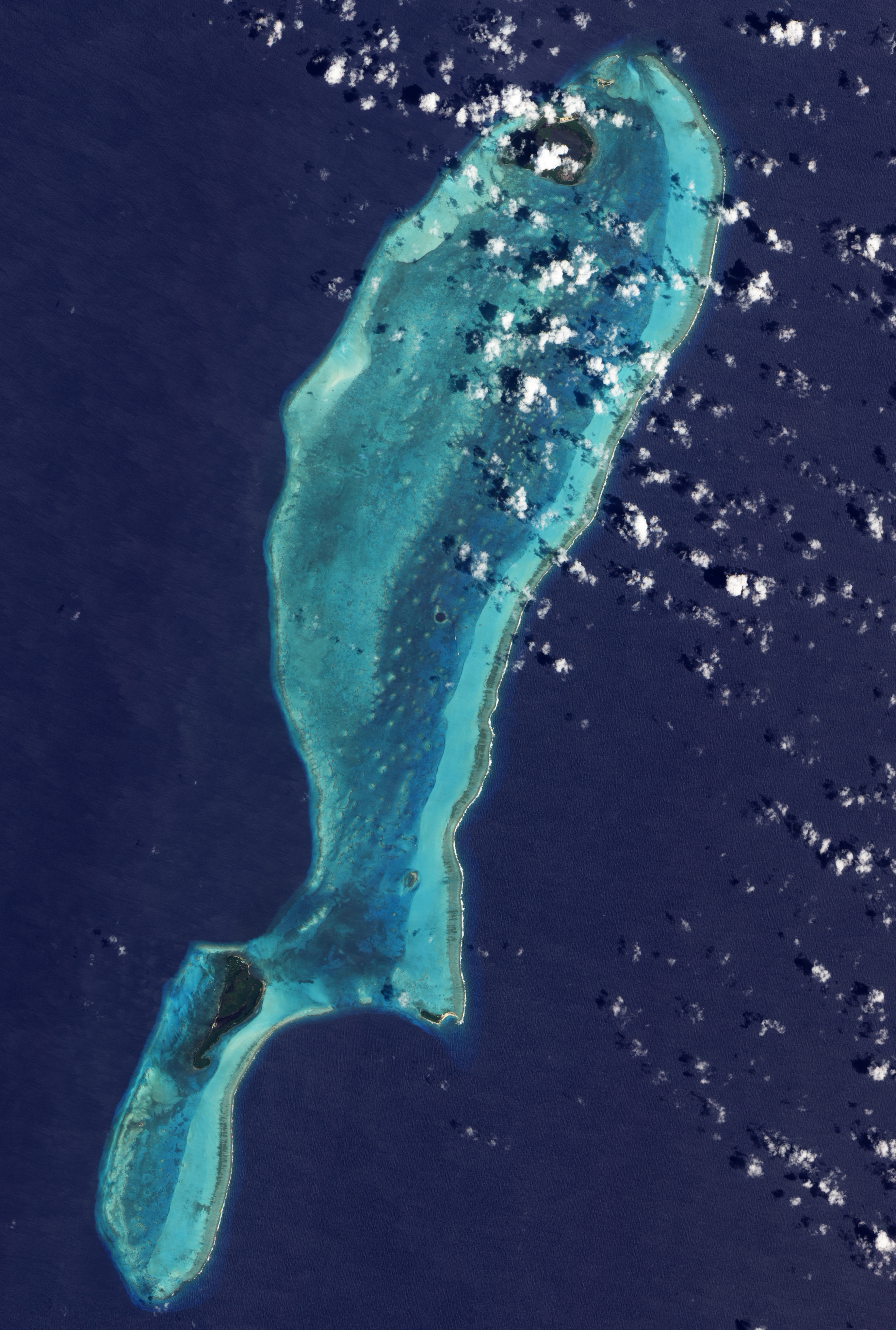
English: NASA image of Lighthouse Reef, Belize, which includes the Great Blue Hole roughly near its center. Created by Jesse Allen, using EO-1 ALI ,data provided courtesy of the NASA EO-1 Team. |
| Date | |
| Source | NASA Earth Observatory |
| Author | Jesse Allen |
The Advanced Land Imager (ALI) on NASA’s Earth Observing-1 satellite captured this image of the Great Blue Hole and Lighthouse Reef in the Caribbean Sea on March 24, 2009. The Great Blue Hole appears at the center of the image, surrounded by a ring of lighter color caused by elevated coral. In fact, parts of the ring surrounding this feature actually crest the water surface at low tide, but a layer of shallow water covers most of Lighthouse Reef Atoll. Boats leave tiny white tracks on the nearby water surface, and two boats appear to travel away from the Hole in this image. East of the boats, a broad band of aquamarine indicates an area of especially shallow water along the reef’s margin. Along its easternmost edge, the reef crests the ocean surface, where breaking waves from the Caribbean Sea form a jagged line of white.
Licensing
[edit]
| This file is in the public domain in the United States because it was solely created by NASA. NASA copyright policy states that "NASA material is not protected by copyright unless noted". (See Template:PD-USGov, NASA copyright policy page or JPL Image Use Policy.) | ||
 |
Warnings:
|
| Annotations | This image is annotated: View the annotations at Commons |
File history
Click on a date/time to view the file as it appeared at that time.
| Date/Time | Thumbnail | Dimensions | User | Comment | |
|---|---|---|---|---|---|
| current | 21:53, 13 April 2009 | | 2,743 × 4,072 (3.88 MB) | Originalwana (talk | contribs) | {{Information |Description={{en|1=NASA image created by Jesse Allen, using EO-1 ALI data provided courtesy of the NASA EO-1 Team.}} |Source=http://earthobservatory.nasa.gov/IOTD/view.php?id=37741&src=iotdrss |Author=Jesse Allen |Date=2009-03-24 |Permissio |
You cannot overwrite this file.
File usage on Commons
The following 3 pages use this file:
File usage on other wikis
The following other wikis use this file:
- Usage on ast.wikipedia.org
- Usage on be.wikipedia.org
- Usage on ca.wikipedia.org
- Usage on ceb.wikipedia.org
- Usage on cs.wikipedia.org
- Usage on de.wikipedia.org
- Usage on en.wikipedia.org
- Usage on es.wikipedia.org
- Usage on hu.wikipedia.org
- Usage on hy.wikipedia.org
- Usage on it.wikipedia.org
- Usage on it.wikivoyage.org
- Usage on ja.wikipedia.org
- Usage on kk.wikipedia.org
- Usage on ko.wikipedia.org
- Usage on mk.wikipedia.org
- Usage on pl.wikipedia.org
- Usage on ro.wikipedia.org
- Usage on ru.wikipedia.org
- Usage on sk.wikipedia.org
- Usage on sl.wikipedia.org
- Usage on sv.wikipedia.org
- Usage on tr.wikipedia.org
- Usage on www.wikidata.org