File:Lickey Bank geograph-2610950-by-Ben-Brooksbank.jpg
Jump to navigation
Jump to search

Size of this preview: 800 × 435 pixels. Other resolutions: 320 × 174 pixels | 640 × 348 pixels | 1,024 × 557 pixels | 1,280 × 696 pixels | 2,352 × 1,279 pixels.
Original file (2,352 × 1,279 pixels, file size: 575 KB, MIME type: image/jpeg)
Captions
Captions
Add a one-line explanation of what this file represents
Summary
[edit]
| Description |
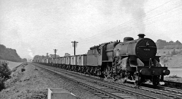
English: Up empties ascending the Lickey Bank with an LMS 2-6-0. View SW, towards Bromsgrove etc.: ex-Midland Birmingham - Bristol main line. (Cf. SO9871 : Train ascending Lickey Incline). This long train of 16-ton steel wagons is headed by LMS Hughes/Fowler Class 5 2-6-0 No. 42846 with the assistance of two ex-GW 0-6-0PT at the rear. |
| Date | |
| Source | From geograph.org.uk |
| Author | Ben Brooksbank |
| Permission (Reusing this file) |
Creative Commons Attribution Share-alike license 2.0 |
| Attribution (required by the license) | Ben Brooksbank / Up empties ascending the Lickey Bank with an LMS 2-6-0 / |
| Camera location | | View this and other nearby images on: OpenStreetMap |
|---|
Licensing
[edit]

|
This image was taken from the Geograph project collection. See this photograph's page on the Geograph website for the photographer's contact details. The copyright on this image is owned by Ben Brooksbank and is licensed for reuse under the Creative Commons Attribution-ShareAlike 2.0 license.
|
This file is licensed under the Creative Commons Attribution-Share Alike 2.0 Generic license.
Attribution: Ben Brooksbank
- You are free:
- to share – to copy, distribute and transmit the work
- to remix – to adapt the work
- Under the following conditions:
- attribution – You must give appropriate credit, provide a link to the license, and indicate if changes were made. You may do so in any reasonable manner, but not in any way that suggests the licensor endorses you or your use.
- share alike – If you remix, transform, or build upon the material, you must distribute your contributions under the same or compatible license as the original.
File history
Click on a date/time to view the file as it appeared at that time.
| Date/Time | Thumbnail | Dimensions | User | Comment | |
|---|---|---|---|---|---|
| current | 12:31, 12 October 2011 | | 2,352 × 1,279 (575 KB) | Chevin (talk | contribs) | == {{int:filedesc}} == {{Information |Description={{en|1=Up empties ascending the Lickey Bank with an LMS 2-6-0 View SW, towards Bromsgrove etc.: ex-Midland Birmingham - Bristol main line. (Cf. SO9871 : Train ascending Lickey Incline). This long train of |
You cannot overwrite this file.
File usage on Commons
There are no pages that use this file.