File:Lewis and Clark Columbia River.jpg
Jump to navigation
Jump to search

Size of this preview: 652 × 600 pixels. Other resolutions: 261 × 240 pixels | 522 × 480 pixels | 835 × 768 pixels | 1,113 × 1,024 pixels | 1,584 × 1,457 pixels.
Original file (1,584 × 1,457 pixels, file size: 1.18 MB, MIME type: image/jpeg)
Captions
Captions
Add a one-line explanation of what this file represents
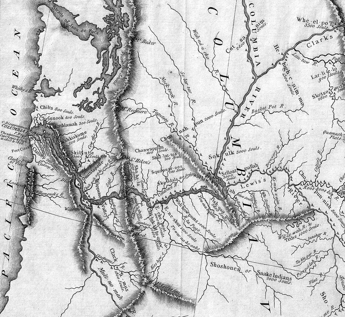
| Description | Detail of the Lewis & Clark expedition map showing the Columbia River. The Willamette River is identified as the "Multnomah River." The Snake River is "Lewis's River." |
| Date | (UTC) |
| Source | |
| Author |
|
|
This work is in the public domain in its country of origin and other countries and areas where the copyright term is the author's life plus 70 years or fewer. | |
| This file has been identified as being free of known restrictions under copyright law, including all related and neighboring rights. | |
Original upload log
[edit]
This image is a derivative work of the following images:
- Image:Map_of_Lewis_and_Clark's_Track,_Across_the_Western_Portion_of_North_America,_published_1814.jpg licensed with PD-old
- 2006-01-06T20:10:08Z Brian0918 7000x3043 (10674416 Bytes) Author: Lewis, Meriwether ; Clark, William ; Biddle, Nicholas ; Allen, Paul Date: 1814 Short Title: Map of Lewis and Clark's Track, Across the Western Portion of North America. Publisher: Philadelphia: Bradford and Insk
Uploaded with derivativeFX
File history
Click on a date/time to view the file as it appeared at that time.
| Date/Time | Thumbnail | Dimensions | User | Comment | |
|---|---|---|---|---|---|
| current | 21:48, 31 May 2008 | | 1,584 × 1,457 (1.18 MB) | Northwest-historian (talk | contribs) | {{Information |Description=Detail of the Lewis & Clark expedition map showing the Columbia River. The Willamette River is identified as the "Multnomah River." The Snake River is "Lewis's River." |Source=*[[:Image:Map_of_Lewis_and_Clark's_Track,_Across_the |
You cannot overwrite this file.
File usage on Commons
There are no pages that use this file.
File usage on other wikis
The following other wikis use this file:
- Usage on ast.wikipedia.org
- Usage on bg.wikipedia.org
- Usage on de.wikipedia.org
- Usage on en.wikipedia.org
- Usage on es.wikipedia.org
- Usage on fr.wikipedia.org
- Usage on it.wikipedia.org
- Usage on ja.wikipedia.org
- Usage on nl.wikipedia.org
- Usage on ru.wikipedia.org
- Usage on vi.wikipedia.org