File:Levens Plan-du-Var.jpg
Jump to navigation
Jump to search

Size of this preview: 800 × 600 pixels. Other resolutions: 320 × 240 pixels | 640 × 480 pixels | 1,024 × 768 pixels | 1,280 × 960 pixels | 2,560 × 1,920 pixels | 3,072 × 2,304 pixels.
Original file (3,072 × 2,304 pixels, file size: 2.12 MB, MIME type: image/jpeg)
Captions
Captions
Add a one-line explanation of what this file represents
Summary
[edit]
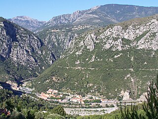
| Description | Hameau de Plan du Var sur la commune de Levens (Alpes-Maritimes, France), au confluent de la Vésubie et du Var. La montagne en haut est à droite est le Férion (1412m). La ligne blanche au milieu de la végétation de la montagne située au premier plan est la canal de la Vésubie, construit à partir des années 1880 pour amener à Nice l'eau des montagnes. |
| Date | |
| Source | Own work |
| Author | Eric Coffinet |
Licensing
[edit]
| This work has been released into the public domain by its author, I, Eric.Coffinet. This applies worldwide. In some countries this may not be legally possible; if so: I, Eric.Coffinet grants anyone the right to use this work for any purpose, without any conditions, unless such conditions are required by law. |
File history
Click on a date/time to view the file as it appeared at that time.
| Date/Time | Thumbnail | Dimensions | User | Comment | |
|---|---|---|---|---|---|
| current | 19:15, 14 July 2007 | | 3,072 × 2,304 (2.12 MB) | Eric.Coffinet~commonswiki (talk | contribs) | {{Information |Description= Hameau de Plan du Var sur la commune de Levens (Alpes-Maritimes, France), au confluent de la Vésubie et du Var. |Source= oeuvre personnelle |Date= 14 juillet 2007 |Author= Eric Coffinet |Permission= |other_versions= }} [[Categ |
You cannot overwrite this file.
File usage on Commons
There are no pages that use this file.
File usage on other wikis
The following other wikis use this file: