File:Lesser Sunda Islands after Cyclone Serjoa (MODIS 2021-04-28).jpg
Jump to navigation
Jump to search

Size of this preview: 749 × 599 pixels. Other resolutions: 300 × 240 pixels | 600 × 480 pixels | 960 × 768 pixels | 1,280 × 1,024 pixels | 2,560 × 2,048 pixels | 4,099 × 3,280 pixels.
Original file (4,099 × 3,280 pixels, file size: 956 KB, MIME type: image/jpeg)
Captions
Captions
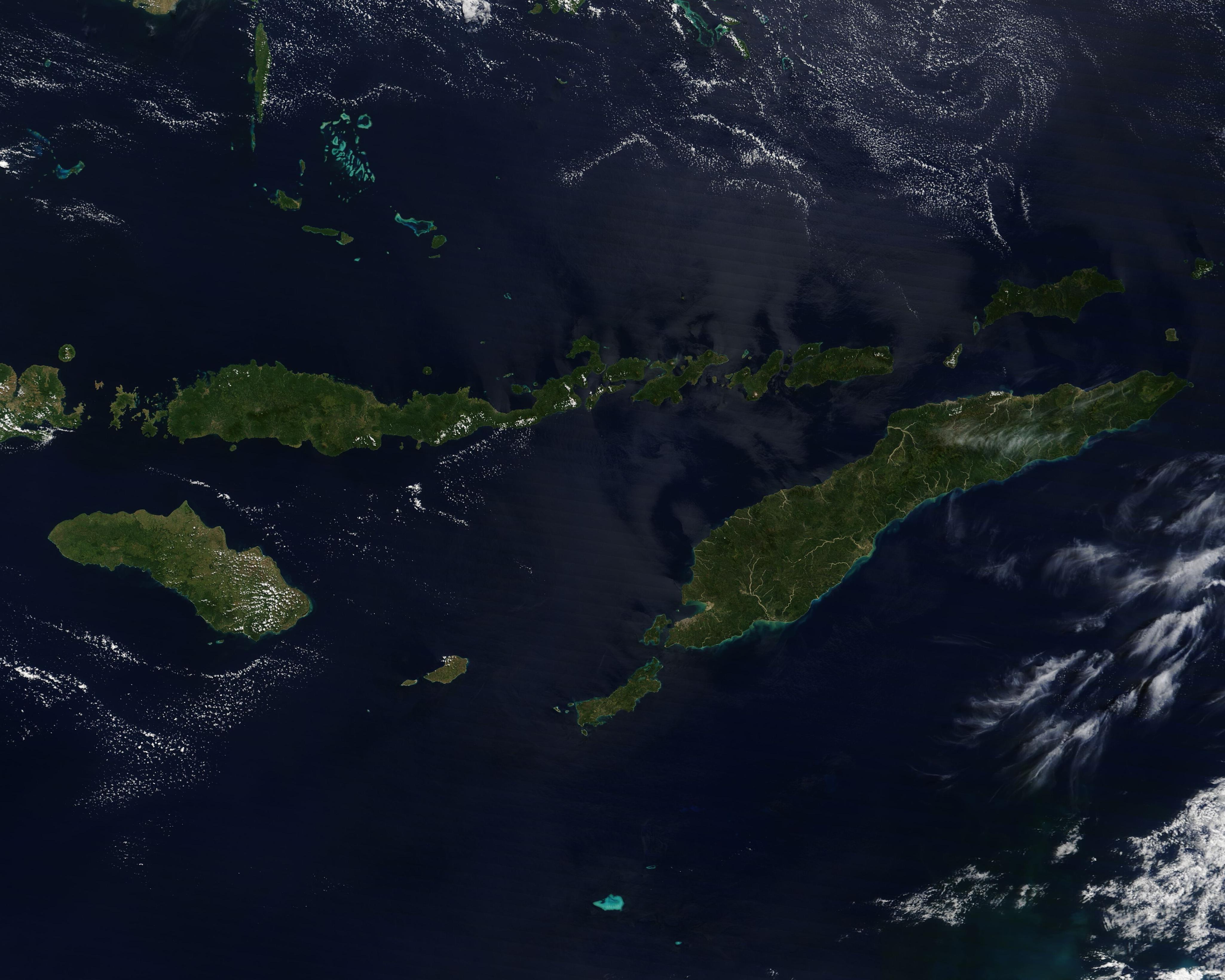
On April 27, 2021, the Moderate Resolution Imaging Spectroradiometer (MODIS) on board NASA’s Terra satellite acquired a true-color image of the Lesser Sunda Islands, a volcanic archipelago sitting in the Indian Ocean northwest of Australia.
Summary
[edit].jpg&action=edit§ion=1)
| Description |
English: On April 27, 2021, the Moderate Resolution Imaging Spectroradiometer (MODIS) on board NASA’s Terra satellite acquired a true-color image of the Lesser Sunda Islands, a volcanic archipelago sitting in the Indian Ocean northwest of Australia. The bulk of the Lesser Sunda Islands belong to Indonesia, with the Democratic Republic of Timor-Leste possessing the eastern half of the island of Timor, an exclave on the Indonesian (western) side of Timor, Atauro Island, and Jaco Island. Timor Island is the largest and most eastern island in this image.
The location and volcanic origin of the Lesser Sunda Islands gives them a warm, humid climate and places them at risk for earthquake, flooding, and tropical cyclones—as well as risk of eruption of a handful of active volcanoes. On April 3, Tropical Cyclone Serjoa formed south of Timor-Leste. It strengthened and moved slowly away from the islands, eventually making landfall in Australia. While the storm did not make landfall in the Lesser Sundas, it brought high wind, storm surge, and heavy rain that sparked severe flash flooding. Offshore waves were reported up to 20 feet (6 meters) high, while some media reported that the storm “turned small communities into wastelands of mud”. More than 100 people have been confirmed killed by the storm, landslides and flooding in eastern Indonesia and Timor-Leste, with many more remaining missing as of April 27. |
||
| Date | Taken on 27 April 2021 | ||
| Source |
Lesser Sunda Islands after Cyclone Serjoa (direct link)
|
||
| Author | MODIS Land Rapid Response Team, NASA GSFC |
| This media is a product of the Terra mission Credit and attribution belongs to the mission team, if not already specified in the "author" row |
Licensing
[edit].jpg&action=edit§ion=2)
| This file is in the public domain in the United States because it was solely created by NASA. NASA copyright policy states that "NASA material is not protected by copyright unless noted". (See Template:PD-USGov, NASA copyright policy page or JPL Image Use Policy.) | ||
 |
Warnings:
|
File history
Click on a date/time to view the file as it appeared at that time.
| Date/Time | Thumbnail | Dimensions | User | Comment | |
|---|---|---|---|---|---|
| current | 17:50, 30 January 2024 | | 4,099 × 3,280 (956 KB) | OptimusPrimeBot (talk | contribs) | #Spacemedia - Upload of http://modis.gsfc.nasa.gov/gallery/images/image04282021_250m.jpg via Commons:Spacemedia |
You cannot overwrite this file.
File usage on Commons
There are no pages that use this file.
.jpg&oldid=847258461)