File:Leizhou Peninsula.jpeg

Original file (3,523 × 4,192 pixels, file size: 4.88 MB, MIME type: image/jpeg)
Captions
Captions
Summary
[edit]
| Description |
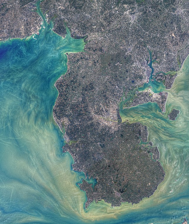
Tides, currents, and human activity combine to produce art-like patterns in the waters around China’s Leizhou Peninsula. The patterns are visible in these images, acquired by the Operational Land Imager (OLI) on Landsat 8 on January 1, 2021. Norman Kuring of NASA’s Ocean Biology group applied color-filtering techniques to draw out the fine details in the water, but the features are real. The image above shows the waters around the entire Leizhou Peninsula, a landform that juts out into the South China Sea from the southernmost portion of mainland China. The Gulf of Tonkin (Beibu Gulf) lies to the west, and the Qiongzhou Strait (Hainan Strait) passes to the south. Numerous bays, harbors, and estuaries line more than 1500 kilometers of coastline along the peninsula. |
| Date | |
| Source | https://earthobservatory.nasa.gov/images/148060/patterns-around-leizhou-peninsula |
| Author | NASA images by Norman Kuring/NASA's Ocean Color Web, using Landsat data from the U.S. Geological Survey. |
Licensing
[edit]
| This file is in the public domain in the United States because it was solely created by NASA. NASA copyright policy states that "NASA material is not protected by copyright unless noted". (See Template:PD-USGov, NASA copyright policy page or JPL Image Use Policy.) | ||
 |
Warnings:
|
File history
Click on a date/time to view the file as it appeared at that time.
| Date/Time | Thumbnail | Dimensions | User | Comment | |
|---|---|---|---|---|---|
| current | 00:52, 25 May 2021 | | 3,523 × 4,192 (4.88 MB) | StellarHalo (talk | contribs) | {{Information |Description=Tides, currents, and human activity combine to produce art-like patterns in the waters around China’s Leizhou Peninsula. The patterns are visible in these images, acquired by the Operational Land Imager (OLI) on Landsat 8 on January 1, 2021. Norman Kuring of NASA’s Ocean Biology group applied color-filtering techniques to draw out the fine details in the water, but the features are real. The image above shows the waters around the entire Leizhou Peninsula, a landfo... |
You cannot overwrite this file.
File usage on Commons
There are no pages that use this file.