File:Leipzig-Matthäikirchhof-WestSeite-Klingertreppe-oben-SüdAufgang-IMG 1057-11x5B-360x180G-PanoS-18-02-2024.jpg
Jump to navigation
Jump to search

Size of this preview: 800 × 400 pixels. Other resolutions: 320 × 160 pixels | 640 × 320 pixels | 1,024 × 512 pixels | 1,280 × 640 pixels | 2,560 × 1,280 pixels | 14,000 × 7,000 pixels.
Original file (14,000 × 7,000 pixels, file size: 64.72 MB, MIME type: image/jpeg)
Captions
Captions
Add a one-line explanation of what this file represents
Summary
[edit]
| Warning | The original file is very high-resolution. It might not load properly or could cause your browser to freeze when opened at full size. |
|---|
| 360° | View in 360° panoramic viewer
|
|---|
| Description |
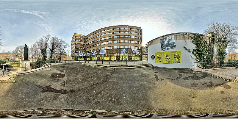
Deutsch: Leipzig/Sachsen, Matthäikirchhof 2024: 360°×180°-Panorama auf der Westseite des bebauten Areals von oberhalb der Klingertreppe (Südaufgang) mit Blick auf den Erweiterungsbau (Westflügel) der ehemaligen Bezirksverwaltung für Staatssicherheit Leipzig, rechts vom Erweiterungsbau ist ein Durchgang zum Innenhof – Zustand Februar 2024 vor der geplanten, grundlegenden Umgestaltung des Areals um den Matthäikirchhof in den nächsten Jahren;
English: Leipzig/Saxony, Matthäikirchhof 2024: 360°×180° panorama on the west side of the built-up area from above the Klingertreppe (south staircase) with a view of the extension building (west wing) of the former Bezirksverwaltung für Staatssicherheit Leipzig (District Administration for State Security Leipzig), to the right of the extension building is a passageway to the inner courtyard - status February 2024 before the planned, fundamental redesign of the area around Matthäikirchhof in the next few years; |
| Date | |
| Source | Own work |
| Author | Joachim Köhler |
| Camera location | | View this and other nearby images on: OpenStreetMap |
|---|
| Attribution (required by the license) | © User:Joachim Köhler / Wikimedia Commons / CC BY-SA 4.0 |
| Using this image |
|
Licensing
[edit]
I, the copyright holder of this work, hereby publish it under the following license:
This file is licensed under the Creative Commons Attribution-Share Alike 4.0 International license.
- You are free:
- to share – to copy, distribute and transmit the work
- to remix – to adapt the work
- Under the following conditions:
- attribution – You must give appropriate credit, provide a link to the license, and indicate if changes were made. You may do so in any reasonable manner, but not in any way that suggests the licensor endorses you or your use.
- share alike – If you remix, transform, or build upon the material, you must distribute your contributions under the same or compatible license as the original.
File history
Click on a date/time to view the file as it appeared at that time.
| Date/Time | Thumbnail | Dimensions | User | Comment | |
|---|---|---|---|---|---|
| current | 16:02, 20 February 2024 | | 14,000 × 7,000 (64.72 MB) | Joachim Köhler (talk | contribs) | Uploaded own work with UploadWizard |
You cannot overwrite this file.
File usage on Commons
The following page uses this file:
File usage on other wikis
The following other wikis use this file:
- Usage on de.wikipedia.org