File:Leimbach Maneggpromenade bridge panosphere 20200818.jpg
Jump to navigation
Jump to search

Size of this preview: 800 × 400 pixels. Other resolutions: 320 × 160 pixels | 640 × 320 pixels | 1,024 × 512 pixels | 1,280 × 640 pixels | 2,560 × 1,280 pixels | 12,666 × 6,333 pixels.
Original file (12,666 × 6,333 pixels, file size: 85.29 MB, MIME type: image/jpeg)
Captions
Captions
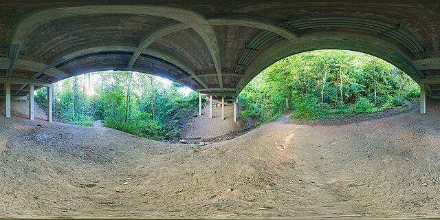
Spherical panoramic under the Maneggpromenade bridge in Leimbach
Summary
[edit]
| Warning | The original file is very high-resolution. It might not load properly or could cause your browser to freeze when opened at full size. |
|---|
| Description |
English: Spherical panoramic at the Rütschlibach in Leimbach, Zürich, under the Maneggpromenade road bridge. At this spot and in the stream there is usually trash carelessly thrown away, as can be seen also in this picture. This panorama was blended from two exposure layers with 16 individual shots each, so consists of 32 images in total. |
| Date | |
| Source | Own work |
| Author | Daniel Kraft |
| Camera location | | View this and other nearby images on: OpenStreetMap |
|---|
| 360° | View in 360° panoramic viewer
|
|---|

|
NOTE: This image is a panorama consisting of 32 frames that were merged or stitched in Hugin. As a result, this image necessarily underwent some form of digital manipulation. These manipulations may include blending, blurring, cloning, and colour and perspective adjustments. As a result of these adjustments, the image content may be slightly different from reality at the points where multiple images were combined. This manipulation is often required due to lens, perspective, and parallax distortions.
|
This image was created with Hugin.
Licensing
[edit]
I, the copyright holder of this work, hereby publish it under the following license:
This file is licensed under the Creative Commons Attribution-Share Alike 3.0 Unported license.
- You are free:
- to share – to copy, distribute and transmit the work
- to remix – to adapt the work
- Under the following conditions:
- attribution – You must give appropriate credit, provide a link to the license, and indicate if changes were made. You may do so in any reasonable manner, but not in any way that suggests the licensor endorses you or your use.
- share alike – If you remix, transform, or build upon the material, you must distribute your contributions under the same or compatible license as the original.
File history
Click on a date/time to view the file as it appeared at that time.
| Date/Time | Thumbnail | Dimensions | User | Comment | |
|---|---|---|---|---|---|
| current | 17:34, 3 October 2020 | | 12,666 × 6,333 (85.29 MB) | Domob (talk | contribs) | Uploaded own work with UploadWizard |
You cannot overwrite this file.
File usage on Commons
The following page uses this file: