File:Le site archéologique de Byrsa (Carthage, Tunisie) (49787855963).jpg

Original file (1,600 × 1,200 pixels, file size: 1.59 MB, MIME type: image/jpeg)
Captions
Captions
Summary
[edit]_(49787855963).jpg&action=edit§ion=1)
| Description |
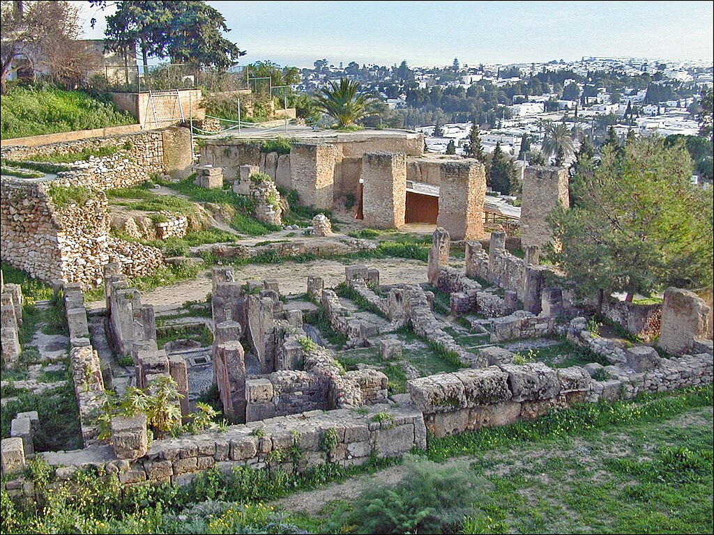
Piles de fondations romaines et quartier punique Colline de Byrsa Le quartier d'habitat punique date des IIIe-IIe s. avant J.C. C'est un ensemble de très petites maisons construites et alignées le long de rues rectilignes. On peut y observer des citernes, un système d'évacuation d'eaux usées, des murs en stuc, des sols en mosaïque ainsi que des traces d'incendie. Après sa destruction, Carthage sera reconstruite par Rome. Colonia Julia Concordia Karthago, ville prospère, à la tête d'une province riche mise en valeur par l'agriculture et la multitude des cités, vêtue d'une parure architecturale, à l'image de Rome, elle sera qualifiée de "Splendissima". Carthage sur le site de l'Institut National du Patrimoine (INP) de Tunisie <a href="http://www.inp.rnrt.tn/index.php?option=com_content&view=article&id=5:carthage&catid=1:sites&Itemid=8&lang=fr#Fondation de Carthage" rel="noreferrer nofollow">www.inp.rnrt.tn/index.php?option=com_content&view=art...</a> sur Wikipedia <a href="https://fr.wikipedia.org/wiki/Byrsa" rel="noreferrer nofollow">fr.wikipedia.org/wiki/Byrsa</a> Site de l'auteur sur Carthage <a href="http://jdalbera.free.fr/tunisie/carthage/birsa.html" rel="noreferrer nofollow">jdalbera.free.fr/tunisie/carthage/birsa.html</a> Fondée dès le IXe siècle av. J.-C. sur le golfe de Tunis, Carthage établit à partir du VIe siècle un empire commercial s'étendant à une grande partie du monde méditerranéen et fut le siège d'une brillante civilisation. Au cours des longues guerres puniques, elle occupa des territoires de Rome, mais celle-ci la détruisit finalement en 146 av. J.-C. Une seconde Carthage, romaine celle-là, fut alors fondée sur ses ruines. Le site archéologqiue de Carthage est inscrit sur la liste du patrimoine mondial de l'UNESCO <a href="https://whc.unesco.org/fr/list/37/" rel="noreferrer nofollow">whc.unesco.org/fr/list/37/</a> |
| Date | |
| Source | Le site archéologique de Byrsa (Carthage, Tunisie) |
| Author | Jean-Pierre Dalbéra |
| Camera location | | View this and other nearby images on: OpenStreetMap |
|---|
_(49787855963).jpg¶ms=036.852797_N_0010.324101_E_globe:Earth_type:camera_source:Flickr_&language=en)
Licensing
[edit]_(49787855963).jpg&action=edit§ion=2)
- You are free:
- to share – to copy, distribute and transmit the work
- to remix – to adapt the work
- Under the following conditions:
- attribution – You must give appropriate credit, provide a link to the license, and indicate if changes were made. You may do so in any reasonable manner, but not in any way that suggests the licensor endorses you or your use.
| This image was originally posted to Flickr by dalbera at https://flickr.com/photos/72746018@N00/49787855963. It was reviewed on 16 January 2024 by FlickreviewR 2 and was confirmed to be licensed under the terms of the cc-by-2.0. |
File history
Click on a date/time to view the file as it appeared at that time.
| Date/Time | Thumbnail | Dimensions | User | Comment | |
|---|---|---|---|---|---|
| current | 04:35, 16 January 2024 | | 1,600 × 1,200 (1.59 MB) | R Prazeres (talk | contribs) | Transferred from Flickr via #flickr2commons |
You cannot overwrite this file.
File usage on Commons
There are no pages that use this file.
_(49787855963).jpg&oldid=888023630)