File:Le royaume des Francs sous Hugues Capet-en.svg
Jump to navigation
Jump to search

Size of this PNG preview of this SVG file: 600 × 600 pixels. Other resolutions: 240 × 240 pixels | 480 × 480 pixels | 768 × 768 pixels | 1,024 × 1,024 pixels | 2,048 × 2,048 pixels | 1,796 × 1,796 pixels.
Original file (SVG file, nominally 1,796 × 1,796 pixels, file size: 1.37 MB)
Captions
Captions
Add a one-line explanation of what this file represents
Summary
[edit]
| Description |
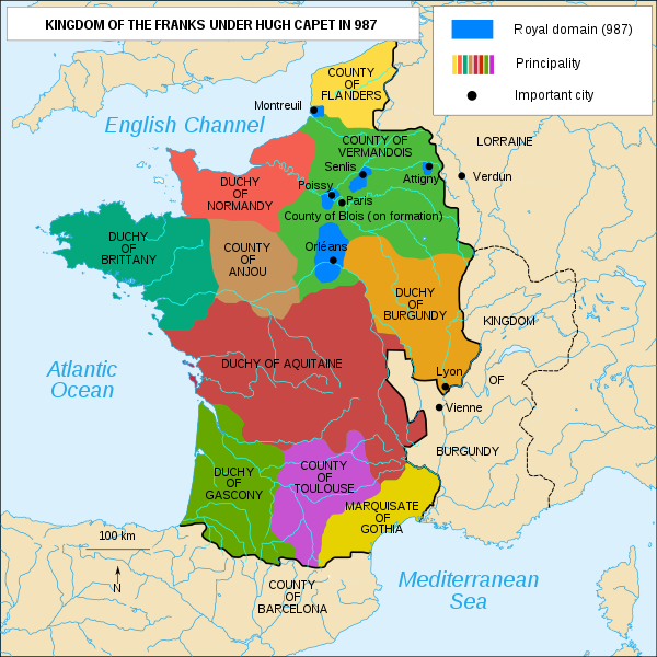
English: The Kingdom of the Franks under Hugh Capet in 987 |
| Date | |
| Source | Le royaume des Francs sous Hugues Capet-fr.svg |
| Author |
Le royaume des Francs sous Hugues Capet-fr.svg: Bourrichon (talk · contribs)
|
Licensing
[edit]
This file is licensed under the Creative Commons Attribution-Share Alike 4.0 International license.
- You are free:
- to share – to copy, distribute and transmit the work
- to remix – to adapt the work
- Under the following conditions:
- attribution – You must give appropriate credit, provide a link to the license, and indicate if changes were made. You may do so in any reasonable manner, but not in any way that suggests the licensor endorses you or your use.
- share alike – If you remix, transform, or build upon the material, you must distribute your contributions under the same or compatible license as the original.
File history
Click on a date/time to view the file as it appeared at that time.
| Date/Time | Thumbnail | Dimensions | User | Comment | |
|---|---|---|---|---|---|
| current | 22:00, 20 August 2017 | | 1,796 × 1,796 (1.37 MB) | Morningstar1814 (talk | contribs) | User created page with UploadWizard |
You cannot overwrite this file.
File usage on Commons
The following page uses this file:
File usage on other wikis
The following other wikis use this file:
- Usage on arz.wikipedia.org
- Usage on azb.wikipedia.org
- Usage on bg.wikipedia.org
- Usage on cs.wikipedia.org
- Usage on en.wikipedia.org
- Usage on es.wikipedia.org
- Usage on he.wikipedia.org
- Usage on ja.wikipedia.org
- Usage on ko.wikipedia.org
- Usage on sk.wikipedia.org
- Usage on tr.wikipedia.org
- Usage on uk.wikipedia.org
- Usage on vi.wikipedia.org
Metadata
Categories:
- SVG maps of the history of France
- Maps of 10th-century France
- Maps showing 10th-century history
- Maps of the kingdom of France
- SVG maps of historical provinces of France
- Duchy of Normandy
- Duchy of Brittany
- Duchy of Aquitaine
- Duchy of Burgundy
- County of Anjou
- Maps of the county of Flanders
- Kingdom of Burgundy
- County of Toulouse