File:Laverstock Mill BSGD - Greenhouses (2) (geograph 4291159).jpg
Jump to navigation
Jump to search

Size of this preview: 425 × 600 pixels. Other resolutions: 170 × 240 pixels | 340 × 480 pixels | 1,000 × 1,411 pixels.
Original file (1,000 × 1,411 pixels, file size: 1.1 MB, MIME type: image/jpeg)
Captions
Captions
Add a one-line explanation of what this file represents
Summary
[edit]_(geograph_4291159).jpg&action=edit§ion=1)
| Description |
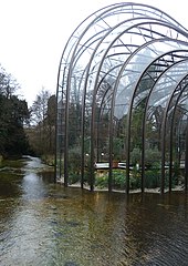
English: Laverstock Mill BSGD - Greenhouses. The larger of the two greenhouses at Laverstoke Mill contains examples of the Mediterranean plants used to flavour the gin that is distilled here. The base of the greenhouse sits on a little islet in a channel of the River Test. |
| Date | Taken on 22 December 2014 |
| Source | From geograph.org.uk |
| Author | Rob Farrow |
| Permission (Reusing this file) |
Creative Commons Attribution Share-alike license 2.0 |
| Attribution (required by the license) | Rob Farrow / Laverstock Mill BSGD - Greenhouses (2) / |
| Camera location | | View this and other nearby images on: OpenStreetMap |
|---|
_(geograph_4291159).jpg¶ms=051.235012_N_-001.296961_E_globe:Earth_type:camera_source:geograph-osgb36(SU49184866)_heading:247.00&language=en)
| Object location | | View this and other nearby images on: OpenStreetMap |
|---|
_(geograph_4291159).jpg¶ms=051.235010_N_-001.297100_E_globe:Earth_class:object_type:object_source:geograph-osgb36(SU49174866)_heading:247.00&language=en)
Licensing
[edit]_(geograph_4291159).jpg&action=edit§ion=2)

|
This image was taken from the Geograph project collection. See this photograph's page on the Geograph website for the photographer's contact details. The copyright on this image is owned by Rob Farrow and is licensed for reuse under the Creative Commons Attribution-ShareAlike 2.0 license.
|
This file is licensed under the Creative Commons Attribution-Share Alike 2.0 Generic license.
Attribution: Rob Farrow
- You are free:
- to share – to copy, distribute and transmit the work
- to remix – to adapt the work
- Under the following conditions:
- attribution – You must give appropriate credit, provide a link to the license, and indicate if changes were made. You may do so in any reasonable manner, but not in any way that suggests the licensor endorses you or your use.
- share alike – If you remix, transform, or build upon the material, you must distribute your contributions under the same or compatible license as the original.
File history
Click on a date/time to view the file as it appeared at that time.
| Date/Time | Thumbnail | Dimensions | User | Comment | |
|---|---|---|---|---|---|
| current | 13:56, 28 March 2022 | | 1,000 × 1,411 (1.1 MB) | Chris j wood (talk | contribs) | == {{int:filedesc}} == {{Information |Description={{en|1=Laverstock Mill BSGD - Greenhouses. The larger of the two greenhouses at Laverstoke Mill contains examples of the Mediterranean plants used to flavour the gin that is distilled here. The base of the greenhouse sits on a little islet in a channel of the River Test.}} |Source=From [https://www.geograph.org.uk/photo/4291159 geograph.org.uk] |Date={{Taken on|2014-12-22|location=United Kingdom}} |Author=[https://www.geograph.org.uk/profile/3... |
You cannot overwrite this file.
File usage on Commons
There are no pages that use this file.
_(geograph_4291159).jpg&oldid=805386799)