File:Late October 2021 nor'easter 2021-10-27 1743Z.jpg
Jump to navigation
Jump to search

Size of this preview: 456 × 600 pixels. Other resolutions: 182 × 240 pixels | 365 × 480 pixels | 584 × 768 pixels | 778 × 1,024 pixels | 1,556 × 2,048 pixels | 3,800 × 5,000 pixels.
Original file (3,800 × 5,000 pixels, file size: 4.3 MB, MIME type: image/jpeg)
Captions
Captions
Add a one-line explanation of what this file represents
Summary
[edit]| Description |
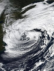
English: Taken from the VIIRS instrument on the Suomi-NPP satellite, this true color image of a Nor'easter was taken on October 27, 2021 at 17:43 (UTC) 1:43 PM (Local Time). When this image was taken the Nor'easter was coming off its peak earlier in the day at 09:00 (UTC) 5:00 AM (Local Time). Throughout the days of October 26 and October 27 this Nor'easter brought flooding and high-winds along the I-95 Corridor from about Washington DC up to Boston, this nor'easter would also become Tropical Storm Wanda in the Far North Atlantic on October 31. The estimated intensity of the Nor'easter at the time this image was taken was 65 MPH (55 KNOTS or 105 KMH) with a minimum central pressure of 980 Millibars (hPa). |
| Date | |
| Source | https://worldview.earthdata.nasa.gov/ |
| Author | NASA/Suomi-NPP |
| Other versions |
|

| Camera location | | View this and other nearby images on: OpenStreetMap |
|---|
Licensing
[edit]
| This file is in the public domain in the United States because it was solely created by NASA. NASA copyright policy states that "NASA material is not protected by copyright unless noted". (See Template:PD-USGov, NASA copyright policy page or JPL Image Use Policy.) | ||
 |
Warnings:
|
File history
Click on a date/time to view the file as it appeared at that time.
| Date/Time | Thumbnail | Dimensions | User | Comment | |
|---|---|---|---|---|---|
| current | 20:34, 7 November 2021 | | 3,800 × 5,000 (4.3 MB) | Hurricaneboy23 (talk | contribs) | Tweaks to levels |
| 16:18, 5 November 2021 |  | 3,800 × 5,000 (4.13 MB) | TheWxResearcher (talk | contribs) | Closer to a 3:4 Ratio | |
| 15:46, 5 November 2021 |  | 4,000 × 5,000 (2.93 MB) | TheWxResearcher (talk | contribs) | Uploaded a work by NASA/Suomi-NPP from https://worldview.earthdata.nasa.gov/ with UploadWizard |
You cannot overwrite this file.
File usage on Commons
There are no pages that use this file.
File usage on other wikis
The following other wikis use this file:
- Usage on en.wikipedia.org
- Usage on fa.wikipedia.org
- Usage on pa.wikipedia.org
- Usage on pt.wikipedia.org
- Usage on shn.wikipedia.org
- Usage on simple.wikipedia.org
- Usage on vi.wikipedia.org
- Usage on zh-min-nan.wikipedia.org