File:Larra-Ukerdi-PXL 20210502 0855-PANO.jpg
Jump to navigation
Jump to search

Size of this preview: 800 × 216 pixels. Other resolutions: 320 × 86 pixels | 640 × 173 pixels | 1,024 × 277 pixels | 1,280 × 346 pixels | 2,560 × 692 pixels | 7,641 × 2,065 pixels.
Original file (7,641 × 2,065 pixels, file size: 3.83 MB, MIME type: image/jpeg)
Captions
Captions
Add a one-line explanation of what this file represents
Summary
[edit]
| Description |
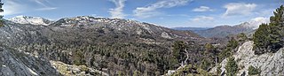
Español: Panorámica de la parte más baja de Larra desde el Alto de la Cruz. Se observa en el centro la vertiente norte de Lapazarra, con hayas y abetos en los surcos y pinos negros en las crestas del atormentado karst subyacente. En el borde izquierdo de la foto el monte La Paquiza (nevado) y en el derecho La Queleta.
|
||
| Date | |||
| Source | Own work | ||
| Author | JLPiedrafita |
| Camera location | | View this and other nearby images on: OpenStreetMap |
|---|
Licensing
[edit]
I, the copyright holder of this work, hereby publish it under the following license:
This file is licensed under the Creative Commons Attribution-Share Alike 4.0 International license.
- You are free:
- to share – to copy, distribute and transmit the work
- to remix – to adapt the work
- Under the following conditions:
- attribution – You must give appropriate credit, provide a link to the license, and indicate if changes were made. You may do so in any reasonable manner, but not in any way that suggests the licensor endorses you or your use.
- share alike – If you remix, transform, or build upon the material, you must distribute your contributions under the same or compatible license as the original.
This image was uploaded as part of Wiki Loves Earth 2021.
|
 |
File history
Click on a date/time to view the file as it appeared at that time.
| Date/Time | Thumbnail | Dimensions | User | Comment | |
|---|---|---|---|---|---|
| current | 13:07, 27 May 2021 | 7,641 × 2,065 (3.83 MB) | JLPiedrafita (talk | contribs) | Uploaded own work with UploadWizard |
You cannot overwrite this file.
File usage on Commons
There are no pages that use this file.