File:Lans-en-Vercors- Eglise -2.JPG
Jump to navigation
Jump to search

Size of this preview: 800 × 600 pixels. Other resolutions: 320 × 240 pixels | 640 × 480 pixels | 1,024 × 768 pixels | 1,280 × 960 pixels | 2,560 × 1,920 pixels | 3,648 × 2,736 pixels.
Original file (3,648 × 2,736 pixels, file size: 1.65 MB, MIME type: image/jpeg)
Captions
Captions
Add a one-line explanation of what this file represents
|
This building is indexed in the base Mérimée, a database of architectural heritage maintained by the French Ministry of Culture, under the reference PA00117209
|
Summary
[edit]| Description |
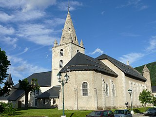
Churchs Saint-Barthélémy. We can see: the nave (late 1790s and early 1800s), the bell tower (late 1590s and early 1600s), the clergy house and the sacristy (late 1790s and early 1800s) with an arcade (late 1590s and early 1600s), a turret (late 1590s and early 1600s) who says a privilege. |
||
| Date | (late 990s and early 1000s), late 1590s and early 1600s, late 1790s and early 1800s | ||
| Place of creation | Lans-en-Vercors, Isere, Auvergne-Rhône-Alpes, France | ||
| References | Rémond, Étienne; Annick Rémond (2010) Lans-en-Vercors depuis l'an 1080 autour de son église et de son prieuré (30 cm) (1st ed.), Notre-Dame à Montbonnot-Saint-Martin ISBN: 978-2-7466-2228-9. | ||
| Source/Photographer | Own work, MOSSOT | ||
| Permission (Reusing this file) |
I, the copyright holder of this work, hereby publish it under the following licenses:
This file is licensed under the Creative Commons Attribution-Share Alike 3.0 Unported, 2.5 Generic, 2.0 Generic and 1.0 Generic license.
You may select the license of your choice. |

| Object location | | View this and other nearby images on: OpenStreetMap |
|---|
File history
Click on a date/time to view the file as it appeared at that time.
| Date/Time | Thumbnail | Dimensions | User | Comment | |
|---|---|---|---|---|---|
| current | 20:00, 19 June 2010 | | 3,648 × 2,736 (1.65 MB) | MOSSOT (talk | contribs) | {{Information |Description={{fr|1=Lans-en-Vercors - Eglise}} |Source={{own}} |Author=MOSSOT |Date= |Permission= |other_versions= }} Category:Lans-en-Vercors |
You cannot overwrite this file.
File usage on Commons
The following 2 pages use this file:
File usage on other wikis
The following other wikis use this file:
- Usage on de.wikipedia.org
- Usage on fr.wikipedia.org
- Usage on la.wikipedia.org
- Usage on www.wikidata.org