File:Landslide in Southern China.jpg
Jump to navigation
Jump to search

Size of this preview: 600 × 600 pixels. Other resolutions: 240 × 240 pixels | 480 × 480 pixels | 768 × 768 pixels | 1,024 × 1,024 pixels | 2,000 × 2,000 pixels.
Original file (2,000 × 2,000 pixels, file size: 1.7 MB, MIME type: image/jpeg)
Captions
Captions
Add a one-line explanation of what this file represents
Summary
[edit]
| Description |
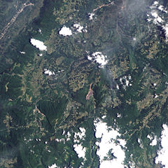
English: A landslide in the Chongqing region of southern China. The landslide dropped some 12 million cubic meters onto several homes and an iron ore mine, trapping dozens of people. Mountain ridges run generally north-south through this area, and the landslide occurs on the western slope of the middle ridge shown in the image. A giant brown scar of bare land on an otherwise vegetated landscape, the landslide fans out toward the south west. The mountainside collapse appears to affect two roads—one road running along the top of the ridge, which borders the landslide, and another road to the west, which the landslide has partially buried. |
| Date | |
| Source | NASA Earth Observatory |
| Author | Jesse Allen |
Image created using EO-1 ALI data provided courtesy of the NASA EO-1 Team. Instrument: EO-1 - ALI
Licensing
[edit]
| This file is in the public domain in the United States because it was solely created by NASA. NASA copyright policy states that "NASA material is not protected by copyright unless noted". (See Template:PD-USGov, NASA copyright policy page or JPL Image Use Policy.) | ||
 |
Warnings:
|
| Annotations | This image is annotated: View the annotations at Commons |
File history
Click on a date/time to view the file as it appeared at that time.
| Date/Time | Thumbnail | Dimensions | User | Comment | |
|---|---|---|---|---|---|
| current | 09:08, 19 June 2009 | | 2,000 × 2,000 (1.7 MB) | Originalwana (talk | contribs) | {{Information |Description={{en|1=A landslide in the Chongqing region of southern China. The landslide dropped some 12 million cubic meters onto several homes and an iron ore mine, trapping dozens of people. Mountain ridges run generally north-south throu |
You cannot overwrite this file.
File usage on Commons
There are no pages that use this file.