File:Landkreis Nordwestmecklenburg administrativ 2014.png
Jump to navigation
Jump to search
Size of this preview: 800 × 593 pixels. Other resolutions: 320 × 237 pixels | 640 × 474 pixels | 1,024 × 759 pixels | 1,280 × 949 pixels | 2,560 × 1,897 pixels | 5,808 × 4,304 pixels.
Original file (5,808 × 4,304 pixels, file size: 1.3 MB, MIME type: image/png)
Captions
Captions
Add a one-line explanation of what this file represents
Summary
[edit]
| Description |
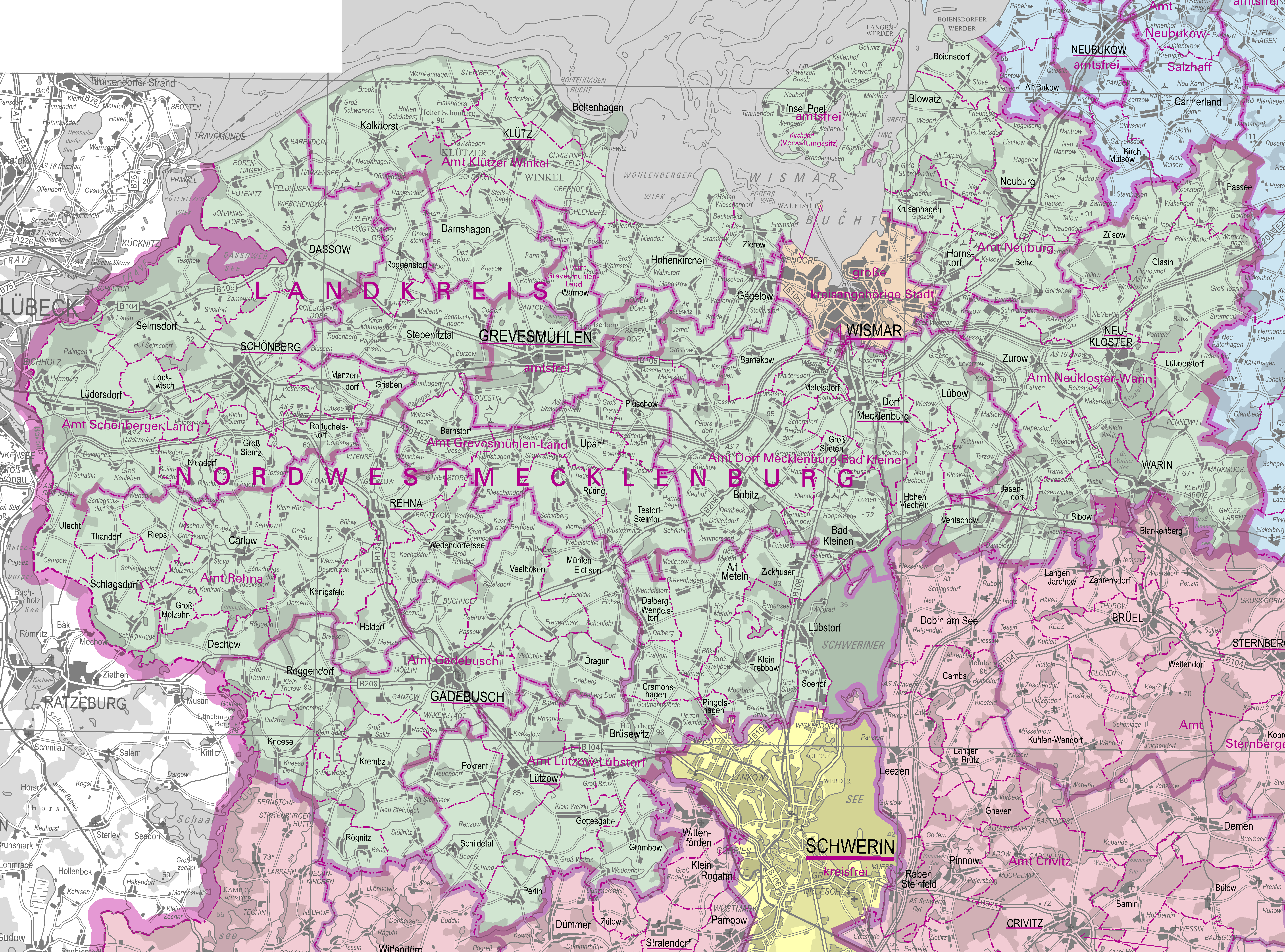
Deutsch: Administrative Karte des Landkreises Nordwestmecklenburg 1:250.000, Stand 25. Mai 2014 |
| Date | |
| Source | Landesamt für innere Verwaltung, Amt für Geoinformation, Vermessungs- und Katasterwesen |
| Author | GeoBasis-DE/M-V |
Licensing
[edit]
This file is licensed under the Creative Commons Attribution-Share Alike 3.0 Unported license.
- You are free:
- to share – to copy, distribute and transmit the work
- to remix – to adapt the work
- Under the following conditions:
- attribution – You must give appropriate credit, provide a link to the license, and indicate if changes were made. You may do so in any reasonable manner, but not in any way that suggests the licensor endorses you or your use.
- share alike – If you remix, transform, or build upon the material, you must distribute your contributions under the same or compatible license as the original.
File history
Click on a date/time to view the file as it appeared at that time.
| Date/Time | Thumbnail | Dimensions | User | Comment | |
|---|---|---|---|---|---|
| current | 17:30, 29 May 2014 | | 5,808 × 4,304 (1.3 MB) | NordNordWest (talk | contribs) | upd |
| 19:27, 11 February 2014 |  | 5,808 × 4,304 (1.3 MB) | NordNordWest (talk | contribs) | == {{int:filedesc}} == {{Information |Description= {{de|1=Administrative Karte des Landkreises Nordwestmecklenburg 1:250.000, Stand 1. Januar2014}} |Source= [http://www.laiv-mv.de/land-mv/LAiV_prod/LAiV/AfGVK/Aktuelle_Karten/1250_000/index.jsp Landesam... |
You cannot overwrite this file.
File usage on Commons
There are no pages that use this file.