File:Landforms-Worldmap.png
Jump to navigation
Jump to search

Size of this preview: 800 × 448 pixels. Other resolutions: 320 × 179 pixels | 640 × 359 pixels | 1,024 × 574 pixels | 1,280 × 717 pixels | 2,560 × 1,434 pixels | 4,127 × 2,312 pixels.
Original file (4,127 × 2,312 pixels, file size: 1.52 MB, MIME type: image/png)
Captions
Captions
Add a one-line explanation of what this file represents
Legende (German)
[edit]
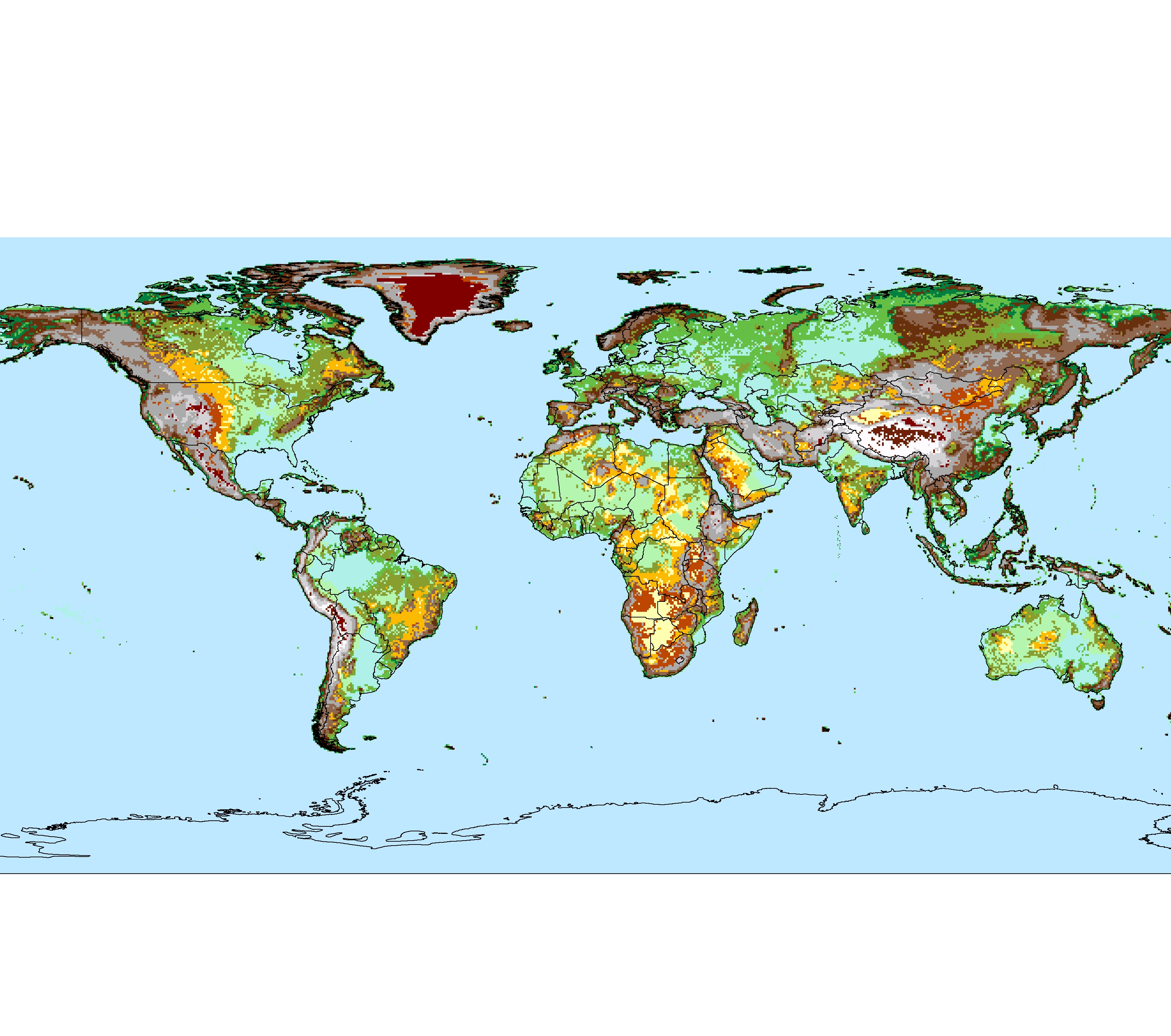
| Farbe | Bezeichnung | absolute Höhen | relative Höhen* | Hangneigung |
|---|---|---|---|---|
| Tiefebenen | 0–200 m | 0–25 m | 0–2 % | |
| Mittelhohe Ebenen u. Tafelland | 200–500 m | 0–25 m | 0–2 % | |
| Hochebenen | > 500 m | 0–25 m | 0–2 % | |
| Hügelland | 0–500 m | 25–100 m | 2–10 % | |
| Vorgebirgs-Plateaus | 500–2000 m | 25–200 m | 2–10 % | |
| Innermontane Plateaus u. Plateaugebirge | 200/500–2000 m | 50–200 m | 2–40 % | |
| Innermontane Hochplateaus | 2000–6000 m | 50–200 m | 2–40 % | |
| Rumpfflächen u. Bergland | 200–500 m | 100–250 m | 2–40 % | |
| Mittelgebirge | 300/600–800/1000 m | 250–750 m | 10–40 % | |
| Hochgebirge | > 800/1000 m | > 750 m | 35–60 % |
*) = bezogen auf einen Radius von 5 km
Legend (English)
[edit]
| Color | Designation | Heights above sea level | Relative heights* | Slopes |
|---|---|---|---|---|
| Low-altitude plains | 0–200 m | 0–25 m | 0–2 % | |
| Mid-altitude plains and Platforms | 200–500 m | 0–25 m | 0–2 % | |
| High-altitude plains | > 500 m | 0–25 m | 0–2 % | |
| Hilly lowlands | 0–500 m | 25–100 m | 2–10 % | |
| Piedmont plateaus | 500–2000 m | 25–200 m | 2–10 % | |
| Intermontane plateaus and Tables | 200/500–2000 m | 50–200 m | 2–40 % | |
| Intermontane high plateaus | 2000–6000 m | 50–200 m | 2–40 % | |
| Rugged lowlands & hills | 200–500 m | 100–250 m | 2–40 % | |
| Low mountains | 300/600–800/1000 m | 250–750 m | 10–40 % | |
| High mountains | > 800/1000 m | > 750 m | 35–60 % |
*) = related to a 5 km radius
Summary
[edit]
| Description |
Deutsch: Die zehn hauptsächlichen Landformen der Erde |
| Date | |
| Source | Own work |
| Author | Fährtenleser |
Quellen
[edit]
Grundkarte
[edit]
- Kartendaten: © OpenStreetMap, Mitwirkende: SRTM | Kartendarstellung: © OpenTopoMap (CC-BY-SA)
Landformen
[edit]
Hoch- und Mittelgebirge
[edit]
- Deniz Karagülle, Charlie Frye, Roger Sayre, Sean Breyer, Peter Aniello, Randy Vaughan und Dawn Wright: Modeling global Hammond landform regions from 250-m elevation data., Transactions in GIS, [DOI: 10.1111/tgis.12265], 2017 – übertragen in Global Montain Explorer, Erfassung der Gebirge der Erde auf zoombaren Karten. Ein Gemeinschaftsprojekt von Mountain Research Initiative (MRI), Center for Development and the Environment (CDE) sowie United States Geological Survey und Environmental Systems Research Institute (ESRI) im Rahmen der Initiative Global Earth Observations - Global Network for Observation and Information in Mountain Environments (GEO-GNOME)
- geringfügig vereinfacht nach opentopomap.org (siehe Kartographie) sowie nach Hans Braxmeier: Relief Map
andere Landformen
[edit]
- Michel Meybeck, Pamela Green, Charles Vörösmarty: A New Typology for Mountains and Other Relief Classes, in Mountain Research and Development, Vol. 1, Nr. 1, 1. Februar 2001, S. 34–45, DOI:10.1659/0276-4741(2001)021[0034:ANTFMA]2.0.CO;2, Karte auf esdac.jrc.ec.europa.eu, abgerufen am 14. Februar 2021
- Grenzen zwischen Tiefebenen und Tafelländern in höherer Auflösung nach: FloodMap.net, Stand 6. Dezember 2020
Licensing
[edit]
I, the copyright holder of this work, hereby publish it under the following license:
This file is licensed under the Creative Commons Attribution-Share Alike 4.0 International license.
- You are free:
- to share – to copy, distribute and transmit the work
- to remix – to adapt the work
- Under the following conditions:
- attribution – You must give appropriate credit, provide a link to the license, and indicate if changes were made. You may do so in any reasonable manner, but not in any way that suggests the licensor endorses you or your use.
- share alike – If you remix, transform, or build upon the material, you must distribute your contributions under the same or compatible license as the original.
File history
Click on a date/time to view the file as it appeared at that time.
| Date/Time | Thumbnail | Dimensions | User | Comment | |
|---|---|---|---|---|---|
| current | 16:15, 2 May 2021 | | 4,127 × 2,312 (1.52 MB) | Fährtenleser (talk | contribs) | Sorry, letzte Version war ohne differenzierte Ebenen |
| 16:08, 2 May 2021 |  | 4,127 × 2,312 (1.29 MB) | Fährtenleser (talk | contribs) | Meeresfarbe heller (besserer Kontrast) / Legende auf Karte | |
| 06:59, 29 April 2021 |  | 4,127 × 2,312 (1.48 MB) | Fährtenleser (talk | contribs) | {{Information |Description=The ten major landforms of earth |Source={{own}} |Date=2021-04-29 |Author= Fährtenleser |Permission= |other_versions= }} Category:Landforms Category:Maps of landforms |
You cannot overwrite this file.
File usage on Commons
There are no pages that use this file.
File usage on other wikis
The following other wikis use this file:
- Usage on de.wikipedia.org