File:Lambwath Bridge, Benningholme - geograph.org.uk - 603309.jpg
Jump to navigation
Jump to search
No higher resolution available.
Lambwath_Bridge,_Benningholme_-_geograph.org.uk_-_603309.jpg (640 × 475 pixels, file size: 95 KB, MIME type: image/jpeg)
Captions
Captions
Add a one-line explanation of what this file represents
Summary
[edit]
| Description |
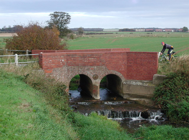
English: Lambwath Bridge, Benningholme, East Riding of Yorkshire, England. Bridge over Lambwath Stream on Swine Road near the junction of Ings Lane and Kidhill Lane, Benningholme Ings, in the northeast corner of Swine parish. An important land drain for the district, Lambwath Stream was recorded as being insufficient as early as 1367 and was earmarked for improvement under the Keyingham Level Drainage Acts of 1772. Like many Holderness drains Lambwath Stream flows west into the floodplain of the River Hull although it originates at Aldbrough only a very short distance from the North Sea. |
| Date | |
| Source | From geograph.org.uk |
| Author | Paul Glazzard |
| Permission (Reusing this file) |
Creative Commons Attribution Share-alike license 2.0 |
| Attribution (required by the license) | Paul Glazzard / Lambwath Bridge, Benningholme / |
| Camera location | | View this and other nearby images on: OpenStreetMap |
|---|
_heading:45.00&language=en)
| Object location | | View this and other nearby images on: OpenStreetMap |
|---|
_heading:45.00&language=en)
Licensing
[edit]

|
This image was taken from the Geograph project collection. See this photograph's page on the Geograph website for the photographer's contact details. The copyright on this image is owned by Paul Glazzard and is licensed for reuse under the Creative Commons Attribution-ShareAlike 2.0 license.
|
This file is licensed under the Creative Commons Attribution-Share Alike 2.0 Generic license.
Attribution: Paul Glazzard
- You are free:
- to share – to copy, distribute and transmit the work
- to remix – to adapt the work
- Under the following conditions:
- attribution – You must give appropriate credit, provide a link to the license, and indicate if changes were made. You may do so in any reasonable manner, but not in any way that suggests the licensor endorses you or your use.
- share alike – If you remix, transform, or build upon the material, you must distribute your contributions under the same or compatible license as the original.
File history
Click on a date/time to view the file as it appeared at that time.
| Date/Time | Thumbnail | Dimensions | User | Comment | |
|---|---|---|---|---|---|
| current | 23:33, 6 February 2011 | | 640 × 475 (95 KB) | GeographBot (talk | contribs) | == {{int:filedesc}} == {{Information |description={{en|1=Lambwath Bridge, Benningholme Bridge over Lambwath Stream on Swine Road near the junction of Ings Lane and Kidhill Lane, Benningholme Ings, in the northeast corner of Swine parish. An important land |
You cannot overwrite this file.
File usage on Commons
There are no pages that use this file.
File usage on other wikis
The following other wikis use this file:
- Usage on en.wikipedia.org