File:Lakshmi Planum and Siddons Patera PIA00240.jpg
Jump to navigation
Jump to search

Size of this preview: 507 × 599 pixels. Other resolutions: 203 × 240 pixels | 406 × 480 pixels | 650 × 768 pixels | 866 × 1,024 pixels | 1,732 × 2,048 pixels | 3,073 × 3,633 pixels.
Original file (3,073 × 3,633 pixels, file size: 3.76 MB, MIME type: image/jpeg)
Captions
Captions
Add a one-line explanation of what this file represents
Summary
[edit]
| Description |
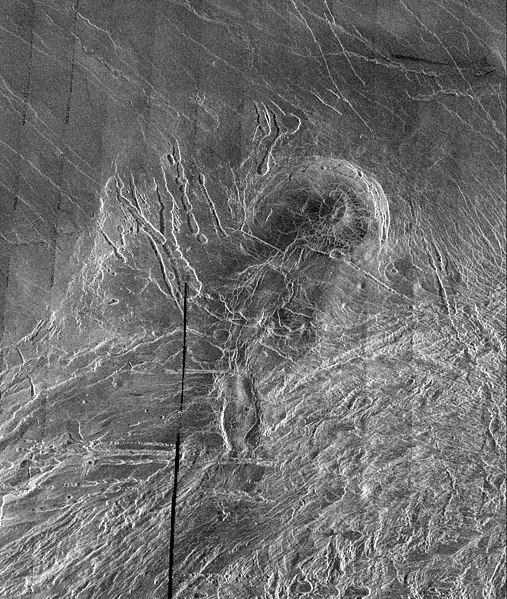
English: This image is a full-resolution mosaic of several Magellan images and is centered at 61 degrees north latitude and 341 degrees east longitude. The image is 250 kilometers wide (150 miles). The radar smooth region in the northern part of the image is Lakshmi Planum, a high plateau region roughly 3.5 kilometers (2.2 miles) above the mean planetary radius. Lakshmi Planum is ringed by intensely deformed terrain, some of which is shown in the southern portion of the image and is called Clotho Tessera. The 64-kilometer (40 mile) diameter circular feature in the image is a depression called Siddons and may be a volcanic caldera. This view is supported by the collapsed lava tubes surrounding the feature. By carefully studying this and other surrounding images scientists hope to discover what tectonic and volcanic processes formed this complex region. The solid black parts of the image represent data gaps that may be filled in by the Magellan extended mission. |
| Source | http://photojournal.jpl.nasa.gov/catalog/PIA00240 |
| Author | Galileo probe |
Licensing
[edit]
| This file is in the public domain in the United States because it was solely created by NASA. NASA copyright policy states that "NASA material is not protected by copyright unless noted". (See Template:PD-USGov, NASA copyright policy page or JPL Image Use Policy.) | ||
 |
Warnings:
|
File history
Click on a date/time to view the file as it appeared at that time.
| Date/Time | Thumbnail | Dimensions | User | Comment | |
|---|---|---|---|---|---|
| current | 05:38, 7 April 2008 | | 3,073 × 3,633 (3.76 MB) | Bryan Derksen (talk | contribs) | {{Information |Description={{en|This image is a full-resolution mosaic of several Magellan images and is centered at 61 degrees north latitude and 341 degrees east longitude. The image is 250 kilometers wide (150 miles). The radar smooth region in the nor |
You cannot overwrite this file.
File usage on Commons
There are no pages that use this file.
File usage on other wikis
The following other wikis use this file:
- Usage on be.wikipedia.org
- Usage on bn.wikipedia.org
- Usage on cs.wikipedia.org
- Usage on fi.wikipedia.org
- Usage on fr.wikipedia.org
- Usage on hi.wikipedia.org
- Usage on hy.wikipedia.org
- Usage on ja.wikipedia.org
- Usage on nl.wikipedia.org
- Usage on ru.wikipedia.org
- Usage on sr.wikipedia.org
- Usage on ta.wikipedia.org
- Usage on uk.wikipedia.org
- Usage on zh.wikipedia.org