File:Lakesalda oli 2020159 lrg.jpeg
Jump to navigation
Jump to search

Size of this preview: 683 × 599 pixels. Other resolutions: 274 × 240 pixels | 547 × 480 pixels | 875 × 768 pixels | 1,167 × 1,024 pixels | 2,334 × 2,048 pixels | 2,668 × 2,341 pixels.
Original file (2,668 × 2,341 pixels, file size: 3.46 MB, MIME type: image/jpeg)
Captions
Captions
Add a one-line explanation of what this file represents
Summary
[edit]
| Description |
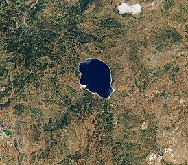
The second image shows Lake Salda on June 8, 2020, as observed by the Operational Land Imager (OLI) on Landsat 8. The lake contains alluvial fans full of rock deposits eroded and washed down from the surrounding bedrock (similar to the delta in Jezero). By studying how material is deposited in Lake Salda, the team can learn more about the various depositional processes at Lake Jezero. The white shoreline around Lake Salda is comprised of sands and gravels that are dominated by hydromagnesite, which is similar to the carbonate minerals detected at Jezero. Horgan explained that the hydomagnesite sediments along Lake Salda’s shoreline are thought to have eroded from large mounds called “microbialites”—rocks formed with the help of microbes. In Lake Salda, they formed from microbial mats that lived just beneath the surface of the water near the shoreline. As the microbialities grew, they incorporated carbonate materials and created large terrace islands. |
| Date | |
| Source | https://earthobservatory.nasa.gov/images/147041/jez-like-mars |
| Author | NASA Earth Observatory image by Lauren Dauphin, using Landsat data from the U.S. Geological Survey. |
Licensing
[edit]
| This file is in the public domain in the United States because it was solely created by NASA. NASA copyright policy states that "NASA material is not protected by copyright unless noted". (See Template:PD-USGov, NASA copyright policy page or JPL Image Use Policy.) | ||
 |
Warnings:
|
File history
Click on a date/time to view the file as it appeared at that time.
| Date/Time | Thumbnail | Dimensions | User | Comment | |
|---|---|---|---|---|---|
| current | 07:13, 25 May 2021 | | 2,668 × 2,341 (3.46 MB) | StellarHalo (talk | contribs) | {{Information |Description=The second image shows Lake Salda on June 8, 2020, as observed by the Operational Land Imager (OLI) on Landsat 8. The lake contains alluvial fans full of rock deposits eroded and washed down from the surrounding bedrock (similar to the delta in Jezero). By studying how material is deposited in Lake Salda, the team can learn more about the various depositional processes at Lake Jezero. The white shoreline around Lake Salda is comprised of sands and gravels that are... |
You cannot overwrite this file.
File usage on Commons
There are no pages that use this file.