File:Lakes Michigan and Huron (MODIS 2024-04-16).jpg

Original file (3,134 × 2,277 pixels, file size: 2.46 MB, MIME type: image/jpeg)
Captions
Captions
Summary
[edit].jpg&action=edit§ion=1)
| Description |
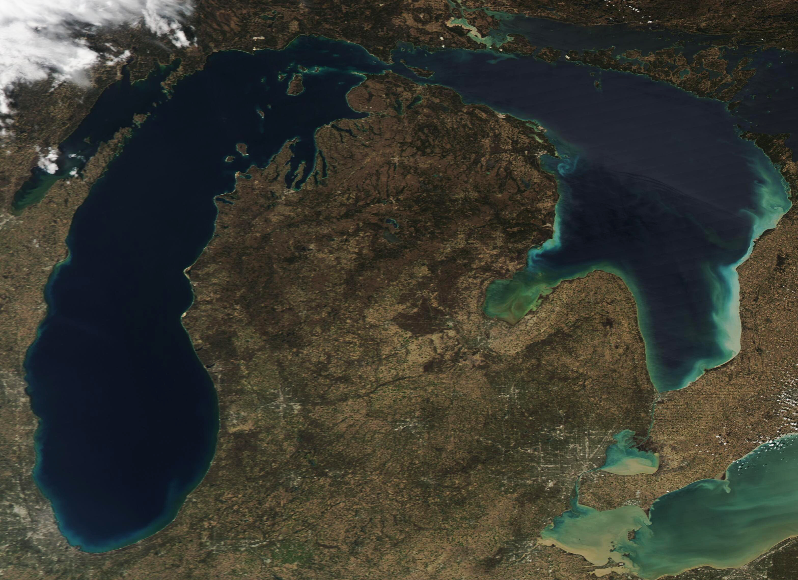
English: After two days of wind and rain, the skies cleared over North America’s Great Lakes on April 13, 2024. The Moderate Resolution Imaging Spectroradiometer (MODIS) on NASA’s Aqua satellite acquired a true-color image of Lakes Michigan and Huron on that same day.
The Great Lakes are a series of five freshwater lakes that sprawl across about 94,250 square miles in east-central North America. Lake Michigan, the third largest of the lakes, is the only lake entirely within the United States. The rest—Lakes Superior, Huron, Erie, and Ontario—sit along the border with Canada. The lakes are interconnected with each other through canals, channels, and rivers and they also are connected to the Atlantic Ocean through the Saint Lawrence River. This image captures the entirety of Lake Michigan, in the west, and Lake Huron. A bit of Lake Erie can be seen in the southeast. Small and round, Lake St. Clair sits between Huron and Erie. Near western Lake Erie, a gray area that resembles a spiderweb is the city of Detroit, Michigan. Sediment fills Lake Erie as well as the smaller Lake St. Clair, staining the waters a muddy tan. Sediment is also visible along the southern coasts of both Lakes Michigan and Huron, almost certainly stirred up by the stormy conditions of the preceding days. Saginaw Bay sits on the western side of Lake Huron and is filled with swirls of yellowish-green. This color is from a bloom of algae, which reproduces in this bay nearly every summer. |
||
| Date | Taken on 13 April 2024 | ||
| Source |
Lakes Michigan and Huron (direct link)
|
||
| Author | MODIS Land Rapid Response Team, NASA GSFC |
| This media is a product of the Aqua mission Credit and attribution belongs to the mission team, if not already specified in the "author" row |
Licensing
[edit].jpg&action=edit§ion=2)
| This file is in the public domain in the United States because it was solely created by NASA. NASA copyright policy states that "NASA material is not protected by copyright unless noted". (See Template:PD-USGov, NASA copyright policy page or JPL Image Use Policy.) | ||
 |
Warnings:
|
File history
Click on a date/time to view the file as it appeared at that time.
| Date/Time | Thumbnail | Dimensions | User | Comment | |
|---|---|---|---|---|---|
| current | 05:05, 16 April 2024 | | 3,134 × 2,277 (2.46 MB) | OptimusPrimeBot (talk | contribs) | #Spacemedia - Upload of http://modis.gsfc.nasa.gov/gallery/images/image04162024_250m.jpg via Commons:Spacemedia |
You cannot overwrite this file.
File usage on Commons
There are no pages that use this file.
.jpg&oldid=909380142)