File:Lake Poopó (MODIS 2016-02-06).jpg

Original file (1,220 × 928 pixels, file size: 123 KB, MIME type: image/jpeg)
Captions
Captions
Summary
[edit].jpg&action=edit§ion=1)
| Description |
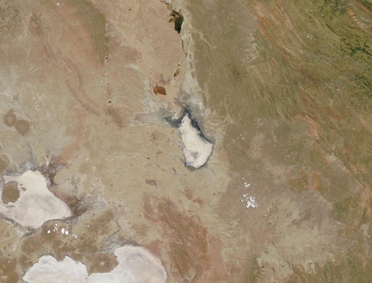
English: Once Bolivia's second-largest lake and a profitable fishery, Lake Poopó now resembles the dry, white salt flats that lie less than 100 mi (161 km) away.
The Moderate Resolution Imaging Spectroradiometer (MODIS) aboard NASA's Terra satellite captured this true-color image on January 22, 2016. Lake Poopó is located in the center of the image, with the nearly dry bed of the Desaguadero River at the northern tip. Two salt flats can be seen in the southwest: Salar de Coipasa and Salar de Uyuni. Salar de Uyuni is the more southerly of the two. In a typical year, the water level in Lake Poopó drops to some degree during the dry season. However, the lake becomes refreshed during the wet season (December through March) by direct rainfall and via inflow from the Desaguadero River. Despite being well into the 2015-2016 wet season, the lake remains dry. By mid-December, 2015, news agencies reported that Lake Poopó had essentially dried up. The reports blamed recurrent drought and the diversion of the lake's water sources for mining and agriculture. On December 19 the government of the Bolivian province of Oruro issued a declaration of natural disaster due to the state of Lake Poopó. The loss of the lake would affect the economy of eight municipalities in the area. It also has affected almost 200 species of birds, mammals, fish and reptiles that once called the lake home. The disaster declaration aids in the mobilization of funds and manpower to try to improve the situation. According to news reports of AgenciaEFE, the Bolivian government has estimated that an investment of the equivalent to about 114 million US dollars would be necessary to save the lake. |
||
| Date | Taken on 22 January 2016 | ||
| Source |
|
||
| Author | Jeff Schmaltz, MODIS Land Rapid Response Team, NASA GSFC |
| This media is a product of the Terra mission Credit and attribution belongs to the mission team, if not already specified in the "author" row |
Licensing
[edit].jpg&action=edit§ion=2)
| This file is in the public domain in the United States because it was solely created by NASA. NASA copyright policy states that "NASA material is not protected by copyright unless noted". (See Template:PD-USGov, NASA copyright policy page or JPL Image Use Policy.) | ||
 |
Warnings:
|
File history
Click on a date/time to view the file as it appeared at that time.
| Date/Time | Thumbnail | Dimensions | User | Comment | |
|---|---|---|---|---|---|
| current | 20:33, 15 February 2024 | | 1,220 × 928 (123 KB) | OptimusPrimeBot (talk | contribs) | #Spacemedia - Upload of http://modis.gsfc.nasa.gov/gallery/images/image02062016_250m.jpg via Commons:Spacemedia |
You cannot overwrite this file.
File usage on Commons
There are no pages that use this file.
.jpg&oldid=909383192)