File:Lake Mohave at Davis Dam, Lake Mead National Recreation Area, Bullhead City, Arizona (17063469017).jpg
Original file (4,000 × 3,000 pixels, file size: 3.64 MB, MIME type: image/jpeg)
Captions
Captions
Summary
[edit].jpg&action=edit§ion=1)
| Description |
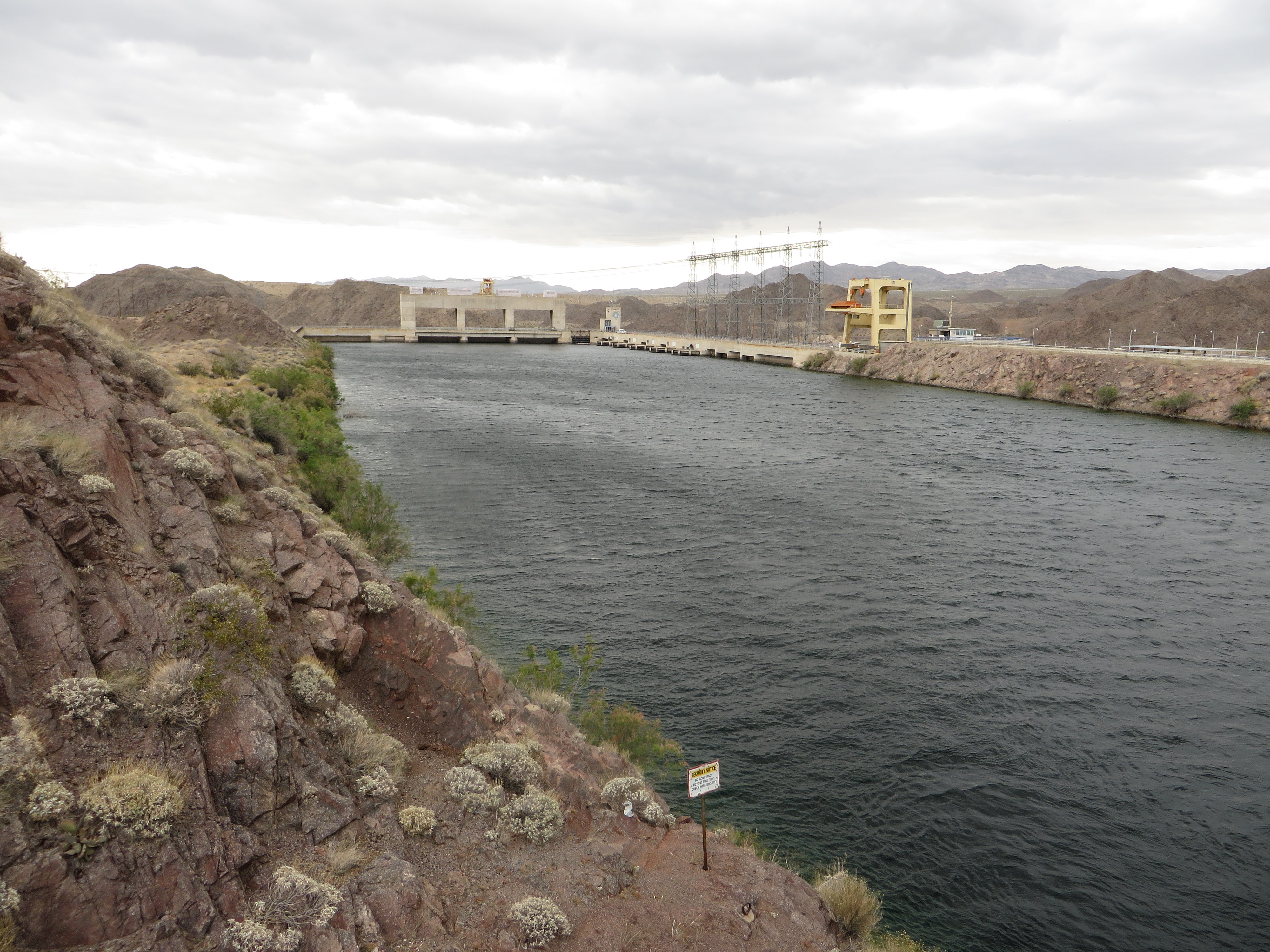
Davis Dam is a dam on the Colorado River about 70 miles (110 km) downstream from Hoover Dam. It stretches across the border between Arizona and Nevada. Originally called Bullhead Dam, Davis Dam was renamed after Arthur Powell Davis, who was the director of the U.S. Bureau of Reclamation from 1914 to 1923. The United States Bureau of Reclamation owns and operates the dam, which was completed in 1951. Davis Dam impounds the Colorado River and forms Lake Mohave. Davis Dam is a zoned earth-fill dam with a concrete spillway, 1,600 ft (490 m) in length at the crest, and 200 ft (61 m) high. The earth fill dam begins on the Nevada side, but it does not extend to the Arizona side on the east. Instead, there is an inlet formed by earth and concrete, that includes the spillway. The hydroelectric power plant is beside the inlet. The dam's purpose is to re-regulate releases from Hoover Dam upstream, and facilitate the delivery of Colorado River water to Mexico. Bullhead City, Arizona, and Laughlin, Nevada, are located just below the dam along the river. Davis Camp is also nearby. Bullhead City was originally a construction town for workers building the dam. A road is located on the crest of the earth fill portion of the dam and a Forebay Bridge spans the Forebay. It was formerly part of Arizona State Route 68 to Nevada. In April of 2004, the roadway was shut down to vehicle traffic. Pedestrian and bicycle traffic are permitted. The old roadway is now an extension of the Heritage Trail system. Barriers have been placed on the former road at each end of the earthen dam. The facility is heavily patrolled by security forces who strictly enforce parking regulations. The Davis Dam Power Plant is a hydroelectric power plant located on the Arizona side of the dam, beside the inlet. The hydroelectric plant generates between 1 and 2 terawatt-hours of electricity annually. The plant has a capacity of 251 MW (337,000 hp) and the tops of its five Francis turbines are visible from outside the plant. The plant's head is 136 ft (41 m). <a href="http://en.wikipedia.org/wiki/Davis_Dam" rel="nofollow">en.wikipedia.org/wiki/Davis_Dam</a> <a href="http://en.wikipedia.org/wiki/Wikipedia:Text_of_Creative_Commons_Attribution-ShareAlike_3.0_Unported_License" rel="nofollow">en.wikipedia.org/wiki/Wikipedia:Text_of_Creative_Commons_...</a> |
| Date | |
| Source | Lake Mohave at Davis Dam, Lake Mead National Recreation Area, Bullhead City, Arizona |
| Author | Ken Lund from Reno, Nevada, USA |
| Camera location | | View this and other nearby images on: OpenStreetMap |
|---|
.jpg¶ms=035.198422_N_-114.566992_E_globe:Earth_type:camera_source:Flickr_&language=en)
Licensing
[edit].jpg&action=edit§ion=2)
- You are free:
- to share – to copy, distribute and transmit the work
- to remix – to adapt the work
- Under the following conditions:
- attribution – You must give appropriate credit, provide a link to the license, and indicate if changes were made. You may do so in any reasonable manner, but not in any way that suggests the licensor endorses you or your use.
- share alike – If you remix, transform, or build upon the material, you must distribute your contributions under the same or compatible license as the original.
| This image was originally posted to Flickr by Ken Lund at https://flickr.com/photos/75683070@N00/17063469017 (archive). It was reviewed on 23 June 2018 by FlickreviewR 2 and was confirmed to be licensed under the terms of the cc-by-sa-2.0. |
File history
Click on a date/time to view the file as it appeared at that time.
| Date/Time | Thumbnail | Dimensions | User | Comment | |
|---|---|---|---|---|---|
| current | 23:51, 23 June 2018 | | 4,000 × 3,000 (3.64 MB) | Hiàn (alt) (talk | contribs) | Transferred from Flickr via #flickr2commons |
You cannot overwrite this file.
File usage on Commons
There are no pages that use this file.
.jpg&oldid=885317431)