File:Lake Kisale NASA.jpg
Jump to navigation
Jump to search

Size of this preview: 800 × 542 pixels. Other resolutions: 320 × 217 pixels | 640 × 433 pixels.
Original file (886 × 600 pixels, file size: 181 KB, MIME type: image/jpeg)
Captions
Captions
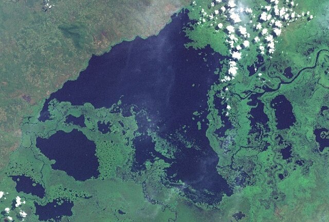
Lake Kisale in the Democratic Republic of Congo
Summary
[edit]
| Description |
Русский: Озеро Кисале в Демократической Республике Конго в окружении меньших озёр (Лунда, Луканга, Сала, Катанга и др.), болот и рек. На космическом снимке видны облака (белый цвет).
English: Lake Kisale in the Democratic Republic of Congo is surrounded by smaller lakes (Lunda, Lukanga, Sala, Katanga, etc.), swamps and rivers. The satellite image shows clouds (white). |
| Date | Unknown date |
| Source | Screenshot from NASA World Wind software, Blue Marble & Landsat layer, Blue Marble layer |
| Author | NASA |
| Object location | | View this and other nearby images on: OpenStreetMap |
|---|
Licensing
[edit]
| This image is in the public domain because it is a screenshot from NASA’s globe software World Wind using a public domain layer, such as Blue Marble, MODIS, Landsat, SRTM, USGS or GLOBE.
|
 |
File history
Click on a date/time to view the file as it appeared at that time.
| Date/Time | Thumbnail | Dimensions | User | Comment | |
|---|---|---|---|---|---|
| current | 16:06, 8 July 2024 | | 886 × 600 (181 KB) | Proeksad (talk | contribs) | Uploaded a work by NASA from Screenshot from NASA World Wind software, Blue Marble & Landsat layer, Blue Marble layer with UploadWizard |
You cannot overwrite this file.
File usage on Commons
There are no pages that use this file.
File usage on other wikis
The following other wikis use this file:
- Usage on ceb.wikipedia.org
- Usage on ru.wikipedia.org
- Usage on www.wikidata.org